Citizens’ group in Fukushima puts out radiation map in English
 The cover of “Citizens’ Radiation Data Map of Japan” (Provided by Minna-No Data Site)
November 3, 2019
FUKUSHIMA—A citizens’ group here has released an English radiation-level map for eastern Japan created with input from 4,000 volunteers in response to requests from abroad ahead of the Tokyo Olympics.
“We want people outside Japan to understand the reality of radioactive contamination following the nuclear accident,” said Nahoko Nakamura, a representative of Minna-No Data Site (Everyone’s Data Site), which published the map.
The Fukushima No. 1 nuclear power plant experienced a triple meltdown in March 2011 after a tsunami knocked out its cooling systems during the Great East Japan Earthquake.
Titled “Citizens’ Radiation Data Map of Japan,” the 16-page booklet summarizes the content of the original Japanese map, released in November last year. It also shows projected declines in radiation levels by 2041.
The Japanese version was based on results of land contamination surveys conducted over three years at the request of Everyone’s Data Site.
About 4,000 volunteers took soil samples at 3,400 locations in 17 prefectures in eastern Japan, including Fukushima and Tokyo, and measured radiation levels. The map was compiled with advice from experts.
The group raised 6.23 million yen ($57,500) from 1,288 individuals through a crowdfunding campaign. So far, 15,000 copies have been sold.
Nakamura said the group decided to produce an English version after it received inquiries about the Japanese map from researchers and others overseas in the run-up to the Tokyo Olympics.
Everyone’s Data Site spent about four months creating the English map, working through e-mail and online chats with five volunteer translators overseas, including an American and a Canadian.
The English edition sells for 500 yen, excluding tax. For more information, contact Everyone’s Data Site at (minnanods@gmail.com).
No human rights in terrifyingly contaminated Namie in Fukushima
The evacuation orders of the most populated areas of Namie, Fukushima were lifted on March 31, 2017.
We are publishing the most recent soil surface density map of Namie created by a citizen’s measurement group named the “Fukuichi Area Environmental Radiation Monitoring Project“(http://www.f1-monitoring-project.jp/index.html). Their members are mainly from Tokyo metropolitan region.

Their map is simply terrifying. This is far much higher level of radio-contamination than in the Radiation Control Zone. Any area becomes designated as such when the total effective dose due to external radiation and that due to radioactive substances in the air is likely to exceed 1.3mSv per quarter – over a period of three months, or when the surface density is likely to exceed 40,000Bq/m2. In the Radiation Control Zone, it is prohibited to drink, eat or stay overnight. Even adults, including nuclear workers, are not allowed to stay more than 10 hours. To leave the zone, one has to go through a strict screening.
Namie’s radio contamination is far over these figures! The average soil contamination density of the total of 314 points where the soil was collected and measured is 858,143Bq/m². The maximum value was 6,780,000Bq/m², and the minimum was only 31,400Bq/m²!
And people, including infants and pregnant women, are told to go back to these areas to live, because it is supposed to be safe. Basically the Japanese government does not recognize the fundamental human right to live in a healthy environment. The population is facing a tough future, for the compensation will be cut off soon, and the housing aid by the central government finishes at the same time. As for the auto-evacuees who fled from areas which are not classified as evacuation zones but are nevertheless radio-contaminated, they had only very little compensation and the housing aid was cut off at the end of March 2017. Continuing to live as nuclear refugees is becoming more and more difficult. We consider that this is a violation of basic environmental human rights.
Let us not forget to thank the members and volunteers of the Fukuichi Area Environmental Radiation Monitoring Project team. They are mostly elderly people over 60 years old. However, that doesn’t mean that they can be exposed to radiation. We thank them and pray for their health.
 Measurement devices
 Kit for soil collection
 Kit carried on the back


 Collected soil samples
 Analysing the soil samples
You might think that Japanese just endure their fate without complaining. This is not true. Many people are fighting and protesting. Let us cite, among numerous on-going trials, the one called the “Trial to require the withdrawal of the 20mSv dose as the limit for evacuation” filed by residents of Minamisoma city in Fukushima, who are against the lifting of the evacuation order when the radiation dose decreases below 20mSv/year. Let us remind you that the Japanese government has adopted 1mSv/year, the internationally recognized dose limitation for public recommended in 1990 by ICRP (International Commission on Radiological Protection), and this is still the limit for the public all over Japan EXCEPT in Fukushima. This is one of the reasons why many people from Fukushima ask themselves: “Is Fukushima really a part of Japan?” or “Are we the people abandoned by the State?”
Related articles of this site :
The scandalous deficiency of the health scheme in Fukushima
Incredible contamination in Namie, Fukushima
Tepco uses radiation imaging drone at Fukushima Daiichi

Tepco uses the RISER quadcopter drone to visually map gamma radiation in the unit 3 turbine building. The RISER quadcopter drone is equipped with GPS, HD cameras and the N-Visage 3D gamma radiation detector which produces color images of radiation. It has a small size 3d gamma camera.
The N-Visage 3D gamma radiation detector technology has been used previously to examine the refueling floor of unit 2 and some other areas of the reactor buildings.
The RISER quadcopter drone has a maximum radiation resistance of 10 mSv/hr so it won’t be used into the more dangerous areas of the site.
Source: http://www.tepco.co.jp/nu/fukushima-np/handouts/2017/images1/handouts_170220_08-j.pdf
Eastern Japan Soil Becquerel Measurement Project Map


Iwaki City

Tomioka

Naraha
Source Minna no Data website:
1 This Month
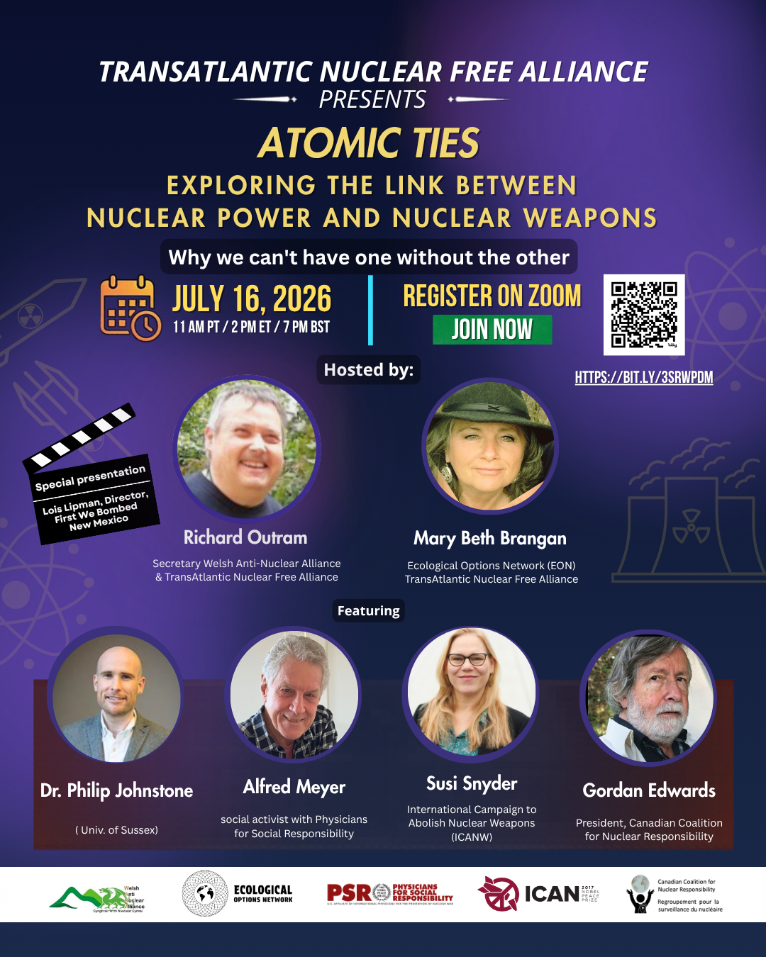
July 16 – 19H BST ATOMIC TIES Webinar!!


22,000+ miles voyaging for nuclear disarmament
and a radiation-free environment https://vfpgoldenruleproject.org/

Cuba Is Not a Failed State – It Is a Besieged State
To see nuclear-related stories in greater depth and intensity – go to https://nuclearinformation.wordpress.com
-
Archives
- July 2026 (115)
- June 2026 (287)
- May 2026 (306)
- April 2026 (356)
- March 2026 (251)
- February 2026 (267)
- January 2026 (308)
- December 2025 (358)
- November 2025 (359)
- October 2025 (376)
- September 2025 (257)
- August 2025 (319)
-
Categories
- 1
- 1 NUCLEAR ISSUES
- business and costs
- climate change
- culture and arts
- ENERGY
- environment
- health
- history
- indigenous issues
- Legal
- marketing of nuclear
- media
- opposition to nuclear
- PERSONAL STORIES
- politics
- politics international
- Religion and ethics
- safety
- secrets,lies and civil liberties
- spinbuster
- technology
- Uranium
- wastes
- weapons and war
- Women
- 2 WORLD
- ACTION
- AFRICA
- Atrocities
- AUSTRALIA
- Christina's notes
- Christina's themes
- culture and arts
- Events
- Fuk 2022
- Fuk 2023
- Fukushima 2017
- Fukushima 2018
- fukushima 2019
- Fukushima 2020
- Fukushima 2021
- general
- global warming
- Humour (God we need it)
- Nuclear
- RARE EARTHS
- Reference
- resources – print
- Resources -audiovicual
- Weekly Newsletter
- World
- World Nuclear
- YouTube
-
RSS
Entries RSS
Comments RSS
