River fishing limits remain 11 years after nuclear disaster

March 7, 2022
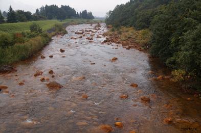
FUKUSHIMA–A sign along the Manogawa river that runs through Minami-Soma, Fukushima Prefecture, is faded, but the message is clear–and perhaps unnecessary.
“Regulations have yet to be lifted,” it says. “Please do not conduct fishing activities.”
The sign is located on a riverbank about 30 kilometers north of the stricken Fukushima No. 1 nuclear power plant run by Tokyo Electric Power Co.
The area used to be crowded with people trying to catch “ayu” (sweetfish). But anglers from near and far stopped visiting the area long ago, and now, hardly anyone is around to see the sign.
After the 2011 nuclear disaster, a local association of fisheries cooperative set up the “no fishing” signs at about 50 locations along the river.
Calls to suspend shipments of river fish and to refrain from fishing have continued since the nuclear disaster started 11 years ago, even for rivers outside the Tohoku region.
In the Manogawa river, ayu, “ugui” (Japanese dace) and “yamame” (masu trout) were found with concentrations of radioactive substances that exceeded the national safety standard.
“There are people who say, ‘I don’t think I can go fishing again in my lifetime,” said Yukiharu Mori, 60, who owns a fishing goods store in Minami-Soma.
His shop’s sales have plummeted, and many other fishing goods shops in the city’s area have gone out of business, he said.
RESTRICTIONS LIFTED FOR SEAFOOD
The nuclear disaster led to restrictions on shipments of seafood products in five prefectures, stretching from Aomori to Ibaraki.
These restrictions have been lifted in stages because radioactive substances more easily diffuse in the sea, and fish species have been confirmed safe to eat.
Currently, the shipment restrictions apply only to “kurosoi” (black rockfish) caught off Fukushima Prefecture.
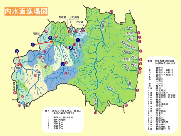
But all restrictions remain for catches from 25 rivers and lakes in five prefectures–Fukushima, Miyagi, Ibaraki, Gunma and Chiba.
In some areas along the Agatsumagawa river in western Gunma Prefecture, shipments of “iwana” (char) and yamame are still restricted.
According to Gunma prefectural officials, radiation doses were relatively high in certain areas around the Agatsumagawa river immediately after the nuclear disaster due to the wind direction and geographical features. That has led in part to the prolonged restrictions.
In a 2020 prefectural survey, the radioactivity concentration level in iwana was 140 becquerels per kilogram. In a 2019 survey, the level for yamame was 120 becquerels per kilogram.
The national standard for both fish is 100 becquerels per kilogram.
“Even when the figure goes down and we think it is safe, we find fish with high figures every few years,” a Gunma prefectural official said. “That makes it difficult for us to take a step toward lifting the restrictions.”
Toshihiro Wada, an associate professor of fish biology at Fukushima University, said river fish “have continued to consume radioactive materials from food” provided through forests that have yet to be decontaminated.
The central government has conducted decontamination work mainly in residential areas of Fukushima Prefecture and surrounding prefectures.
But such work has not been done in most parts of large forested areas. Insects and other critters ingest still-contaminated tree leaves or algae at river bottoms. The river fish then consume the creatures, which has kept radioactive concentrations high in the fish.
A team of researchers from Fukushima University, the Fukushima prefectural government and the National Institute for Environmental Studies has surveyed areas along the Otagawa river that stretches from Namie to Minami-Soma in Fukushima Prefecture since 2018.
The study includes checking radioactivity levels in the river fish and insects.
The upper part of the Otagawa river is located in a “difficult-to-return” zone because of still-high radiation levels.
In an on-site survey in December, the researchers found the radiation dose rate in the air of an upstream forested area within the difficult-to-return zone was 2 to 3 microsieverts per hour. That level was 20 to 30 times higher than the dose rate in the city of Fukushima.
The researchers also found up to 9,000 becquerels of radioactive materials per kilogram in yamame caught in the upper portion of the river in 2018, and up to 12,000 becquerels per kilogram in iwana.
The radioactivity concentrations in tree leaves and river algae were several thousand to tens of thousands of becquerels. Crickets, bees and other land and aquatic creatures found in the yamame’s stomachs are believed to have eaten the contaminated leaves and algae.
Insects in the area contained radioactivity levels of several hundred to several thousand becquerels, the researchers said.
Yumiko Ishii, a team member and a chief researcher at the NIES, said that larger yamame had radioactivity concentration levels that were higher than those in the food that the fish ate.
“Unless you do something about the radioactive materials in forests, the radioactivity concentration levels in fish will not go down,” she said. “But decontaminating forests is not realistic, either.”
(This article was written by Keitaro Fukuchi and Nobuyuki Takiguchi.)
Radiation along Fukushima rivers up to 200 times higher than Pacific Ocean seabed – Greenpeace

Sediment Sampling at Lake Biwa in Japan: Mai Suzuki from Greenpeace Japan, removes sediment samples from the ROV grabber (Remote Operated Vehicle), at Lake Biwa. Greenpeace has been surveying lake Biwa to conduct baseline sampling. The lake is located as close as 30 km from the Takahama nuclear plant owned by Kansai Electric. In the event of a severe accident Lake Biwa would be at risk of major radioactive contamination. The lake provides the drinking water for 14,5 million people in Shiga Prefecture, the city of Kyoto and the wider Kansai region. The citizens of Shiga recently won a historic legal action that forced the immediate shutdown of Takahama reactor #3, Kansai electric is determined to overturn the legal action on appeal and restart both Takahama 3 and 4 reactor.
Tokyo, 21 July 2016 – Radioactive contamination in the seabed off the Fukushima coast is hundreds of times above pre-2011 levels, while contamination in local rivers is up to 200 times higher than ocean sediment, according to results from Greenpeace Japan survey work released today.
“The extremely high levels of radioactivity we found along the river systems highlights the enormity and longevity of both the environmental contamination and the public health risks resulting from the Fukushima disaster,” said Ai Kashiwagi, Energy Campaigner at Greenpeace Japan.
“These river samples were taken in areas where the Abe government is stating it is safe for people to live. But the results show there is no return to normal after this nuclear catastrophe,” said Kashiwagi.
Riverbank sediment samples taken along the Niida River in Minami Soma, measured as high as 29,800 Bq/kg for radiocaesium (Cs-134 and 137). The Niida samples were taken where there are no restrictions on people living, as were other river samples. At the estuary of the Abukuma River in Miyagi prefecture, which lies more than 90km north of the Fukushima Daiichi plant, levels measured in sediment samples were as high as 6,500 Bq/kg.
The lifting of evacuation orders in March 2017 for areas that remain highly contaminated is a looming human rights crisis and cannot be permitted to stand. The vast expanses of contaminated forests and freshwater systems will remain a perennial source of radioactivity for the foreseeable future, as these ecosystems cannot simply be decontaminated.
Caesium-137 has a half life of 30 years, and will continue to pose a risks to the the environment and human health for hundreds of years. Cs-137 contamination in seabed samples near the Fukushima plant was measured at up to 120 Bq/kg – compared to levels pre-2011 of 0.26 Bq/kg. Further, the levels of contamination found 60km south of the Fukushima Daiichi nuclear plant were comparable with those found within 4km of the plant. Numerous marine science investigations, have concluded that these higher levels are one explanation for some marine species still showing higher cesium levels than the background levels in seawater.
“The radiation levels in the sediment off the coast of Fukushima are low compared to land contamination, which is what we expected and consistent with other research,” said Kendra Ulrich, Senior Global Energy Campaigner at Greenpeace Japan. “The sheer size of the Pacific Ocean combined with powerful complex currents means the largest single release of radioactivity into the marine environment has led to the widespread dispersal of contamination.”
Most of the radioactivity in Fukushima Daiichi reactor units 1-3 core fuel in March 2011 remains at the site.
“The scientific community must receive all necessary support to continue their research into the impacts of this disaster,” said Ulrich.
“In addition to the ongoing contamination from forests and rivers, the vast amount of radioactivity onsite at the destroyed nuclear plant remains one of the greatest nuclear threats to Fukushima coastal communities and the Pacific Ocean. The hundreds of thousands of tonnes of highly contaminated water, the apparent failure of the ice wall to reduce groundwater contamination, and the unprecedented challenge of three molten reactor cores all add up to a nuclear crisis that is far from over,” said Ulrich.
A radiation survey team onboard the research vessel Asakaze, supported by the Greenpeace flagship Rainbow Warrior, conducted underwater survey work along the Fukushima coastline from 21 February to 11 March this year, as well collecting samples in river systems. The samples were measured at an independent laboratory in Tokyo.
Link to the report, Atomic Depths, can be found here http://www.greenpeace.org/japan/Global/japan/pdf/20160721_AtomicDepths_ENG.pdf
http://www.greenpeace.org/japan/ja/news/press/2016/pr201607211/

Greenpeace Japan members carry out ROV (Remote Operated Vehicle) operations at Lake Biwa, Shiga Prefecture in Japan. Greenpeace has been surveying lake Biwa to conduct baseline sampling.
New technologies using zeolite composite fibers to prevent radioactive cesium pollution in Fukushima rivers
The authors have developed and applied new technologies using zeolite composite fibers to prevent radioactive Cs pollution of water in Fukushima, Japan.
During approximately four years in the area, decontamination has been conducted to reduce radioactive cesium (Cs) in the field. However, water contaminated with extra-diluted radioactive Cs has prevented residence within about 30 km of the damaged nuclear facilities. Great efforts at decontamination work should be undertaken to alleviate social anxiety and to produce a safe society in Fukushima.
Decontamination using fiber-like decontamination adsorbents was examined in actual use for radioactive Cs in water in Date city in 2013 and in Okuma town in 2015.
This report describes preparation and properties of the fiber-like decontamination adsorbents. Furthermore, this report is the first describing results of radioactive Cs decontamination using a fiber-like adsorbent for water with extra-low-level concentrations of radionuclides.
Even four years after the accident, results strongly suggest the decontamination still distributed in Fukushima area, depending on the distance of the nuclear power plant. Evidence indicates the importance of preventing extension of radioactive Cs further downstream to human residential areas.
Radioactive sediment found in Fukushima rivers
Tokyo: Japanese researchers have detected relatively high levels of radioactive substances in sediment in multiple rivers running through Fukushima prefecture, the media reported on Friday.
The prefectural government in January surveyed the density of radioactive materials in soil and other sediment that has accumulated on the bottoms and banks of 72 rivers in the prefecture, public broadcaster NHK reported.
The study came in response to the 2011 nuclear accident at the Fukushima Daiichi power plant.
The researchers found up to 54,500 becquerels per kg of radioactive substances in the Maeda river in Futaba town, where the plant is situated, and 39,600 becquerels in the Hiru river in Fukushima city. They also detected more than 10,000 becquerels at five other locations in four municipalities.
The prefectural government plans to study restricting access to rivers with high concentrations of radioactive materials.
It also plans to urge the central government to remove contaminated soil and other sediment.
http://www.thejapannews.net/index.php/sid/242732285
Past References
Overview of active cesium contamination of freshwater fish in Fukushima and Eastern Japan
- Received: 13 March 2012
- Accepted: 05 April 2013
- Published online: 29 April 2013
Abstract
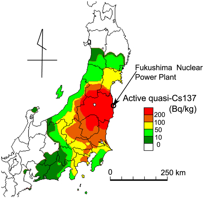
This paper focuses on an overview of radioactive cesium 137 (quasi-Cs137 included Cs134) contamination of freshwater fish in Fukushima and eastern Japan based on the data published by the Fisheries Agency of the Japanese Government in 2011. In the area north and west of the Fukushima Nuclear plant, freshwater fish have been highly contaminated. For example, the mean of active cesium (quasi-Cs137) contamination of Ayu (Plecoglossus altivelis) is 2,657 Bq/kg at Mano River, 20–40 km north-west from the plant. Bioaccumulation is observed in the Agano river basin in Aizu sub-region, 70–150 km west from the plant. The active cesium (quasi-Cs137) contamination of carnivorous Salmondae is around 2 times higher than herbivorous Ayu. The extent of active cesium (quasi-Cs137) contamination of Ayu is observed in the entire eastern Japan. The some level of the contamination is recognized even in Shizuoka prefecture, 400 km south-west from the plant.
Introduction
The serious accidents of the Fukushima Nuclear Power Plant have been contaminating a vast area in eastern Japan1, home of 60 million people. Consumption of freshwater fish is an important part of the aquatic pathway for the transfer of radionuclides to the freshwater ecosystem creatures including humans2. Therefore the contamination of freshwater fish of aquatic bioaccumulation is an important problem3,4. In the case of the Chernobyl Accident, the transfer of radionuclides to fish has been studied in European countries5,6,7. Most attention was focused on Belarus, the Russian Federation and Ukraine, because of the higher contamination of water bodies in these areas8,9. However, in the case of Fukushima, there is little information about freshwater ecosystem contamination in 2011. Therefore, this paper focuses on an overview of active cesium 137 (quasi-Cs137) contaminations of freshwater fish in Fukushima and eastern Japan based on 2011 data published by the Fisheries Agency of the Japanese Government10.
Results
Highest contaminated area in fukushima prefecture
Fukushima Prefecture is located in the northeastern part of the Main Island of Japan (Fig. 1). It is divided into three sub-regions by its mountainous topography, i.e., Hamadori, Nakadori and Aizu (from east to west). Hamadori is the coastal region facing the Pacific Ocean and separated from Nakadori (central basin) by the Abukuma Highlands. The westernmost Aizu is mountainous with the Aizu Basin in the center. There still is a rich natural environment maintained throughout the prefecture with three national parks, one quasi-national park and eleven prefectural parks present. The mountain ranges form headwaters and basins of many rivers such as the Abukuma River and the Aga River. The Abukuma Highlands is designated as one of the prefectural parks and rich in endemic wildlife including the indigenous forest green tree frog (Rhacophorus arboreus) and salamanders (Hynobius lichenatus, Hynobius nigrescens). There the Ayu (Plecoglossidae: Plecoglossus altivelis altivelis), Salmon (Salmonidae: Oncorhynchus masou, Salvelinus leucomaenis) and carp (Cyprinidae: Tribolodon hakonensis, Cyprinus carpio, Carassius.sp) are very popular freshwater fish for fishing and angling.
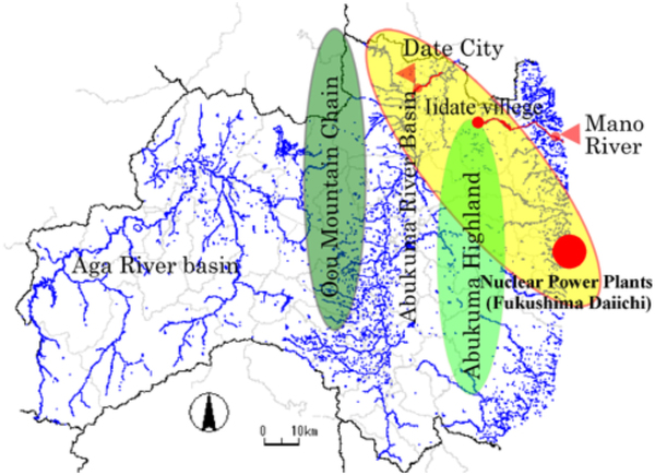
Blue is water system: Aga river basin is west area of Fukushima, Abkuma river basin is center of Fukushima. Green is mountain chain or highland where heights is more 1,000 m. Yellow is high contaminated area by nuclear accidents.
The Fukushima Nuclear Power Plant is located in Hamadori. Due to the topography with the Pacific Ocean in the east and the Abukuma Highlands in the west, the areas in the north to the west of the plant are highly contaminated. Such areas include Iidate Village and Date City. The Mano River which flows through Iidate Village in the upstream and Minami-souma City. Two months after the accident, the Ministry of Land, Infrastructure and Transport surveyed the Mano River11. The survey results of the contamination level of the bottom soil are Cs134: 6,900 Bq/kg and Cs137: 7,800 Bq/kg in Mano River of Minamisouma city at Majima bridge on 29/5/2011. While the area downstream and the Abukuma River in Date City found higher contamination. Two months after the accident, the Ministry of Environment surveyed the Abukuma River of Date city. The survey results of the contamination level of the bottom soil are Cs134: 11,000 Bq/kg and Cs137: 12,000 Bq/kg in Abukuma River of Date city at Taisho bridge on 24/5/2011.
The contamination level of radioactive cesium (quasi-Cs137) of the Ayu, annual and herbivorous species, captured in these rivers or their tributaries between May and September 2011 was measured. The cesium bioaccumulation of those captured in the Mano River was mean 2,657 Bq/kg (n = 3, median 2,900 Bq/kg, range 1,770–3,300 Bq/kg) and the Abukuma River at Date city was mean 1,770 Bq/kg, (n = 11, median 1,170 Bq/kg, range 650–2,080 Bq/kg ).
The bioaccumulations of Aga river basin (West Fukushima)
The Aga River Basin encompasses the entire Aizu region in west Fukushima. The river water flows through from the Aizu region to the Sea of Japan. As it lies over 70 km to the west of the nuclear power plant and both the Abukuma Highlands and Oou montain chain are in between, the Cs137 contamination level here was lower than Mano river and the Abukuma river basin. Two months after the accident, Fukushima prefecture surveyed the Agano River (Aga river Basin) of Aizu and South Aizu region12. The survey results of the contamination level of bottom soil were Cs134: 29 Bq/kg and Cs137: 33 Bq/kg in Agano River of Aizu region at Miyako bridge on 27/5/2011, Cs134: 29 Bq/kg and Cs137: 34 Bq/kg in Agano river of Minami-Aizu region at Tajima bridge on 27/5/2011.
In the aga river basin, the bioaccumulation of fish are well recognized. Fig. 2 shows the quasi-Cs137 contamination and bioaccumulation levels of three fish families captured in the basin, i.e., Plecoglossidae (Plecoglossus altivelis n = 18), Cyprinidae (Tribolodon hakonensis n = 25, Cyprinus carpio n = 5, Carassius sp. n = 11)and Salmonidae(Oncorhynchus masou n = 12, Salvelinus leucomaenis n = 13) between April and December 2011. Since p-value = 0.008 ≤ 0.05 of Kruskal-Wallis Test, at the p = 0.05 level of significance, there exists enough evidence to conclude that there is a difference among the three families based on the active cesium contamination level. The median of herbivorous Plecoglossidae shows the lowest level among the three families (n = 18, mean 50.64 Bq/kg, median = 46.00 Bq/kg, range 12.00–90.00 Bq/kg). Then the median of omnivorous Cyprinidae shows about 1.6 times (n = 41, mean 79.80 Bq/kg, median 72.00 Bq/kg, range 15.00–210.00 Bq/kg) and the mean of carnivorous Salmonidae about 1.9 times higher (n = 25, mean 96.24 Bq/kg, median 89.00 Bq/kg, 17–200 Bq/kg) than Plecoglossidae.
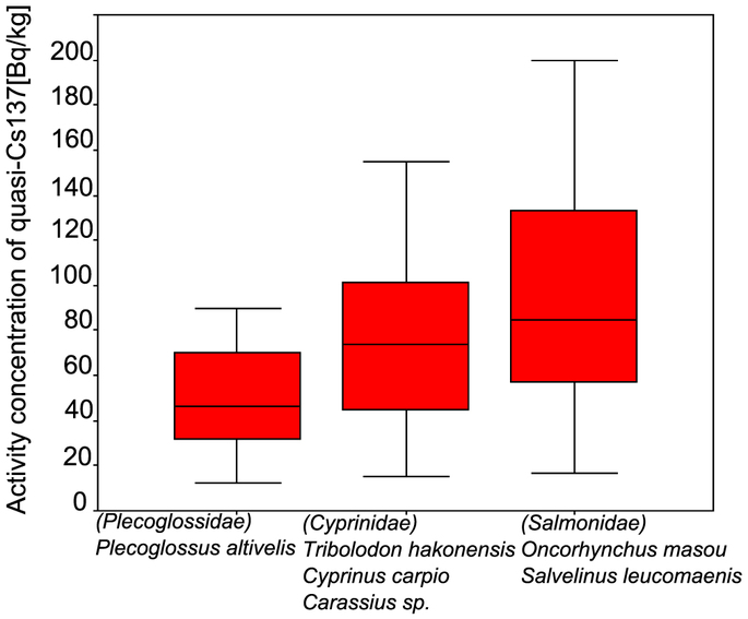
The box plots indicate inter-quartile ranges of these data. Bars are into the each box indicate the each median.
The widespread contamination in eastern Japan
To the south west of Fukushima prefecture, there lies the Kanto region which as well as containing the metropolitan prefecture of Tokyo also comprises Ibaraki prefecture, Tochigi prefecture, Gunma prefecture, Saitama prefecture, and Chiba prefecture. In the area, there is the Tone river basin that is the one of biggest river basins (16,840 km2) in Japan. Therefore, there are not only many source points of water springs and many rivers and streams but also high density water network systems of irrigation canals and urban water systems. Freshwater fish inhabit all types of water systems. As a result, the level of freshwater contamination can be taken as an index of the environmental contamination of the freshwater ecosystem. The isogram map (Fig. 3) shows an average of quasi-Cs137 for each prefecture about contamination levels of the Ayu (Plecoglossus) captured in between May and September 2011.
Each isogram center points are each prefecture’s capital city.
The relation between distance from power plant and contamination level
We found a relation between the distance from the power plant and the quasi-Cs137 contamination level of freshwater fish. According to the result of inverse regression analysis about quasi-Cs137 contamination levels related to the distance from the nuclear power plants of each prefectural capital city, the equation is: Y = 27339.82−1 × −75.13 (Y = Cesium, X = The Distance from the plants to each prefecture’s capital city, Signif F = 0.009 < 0.05, Adjusted R Square 0.50). In areas within a radius of 100 km from the nuclear plant, active cesium contamination levels of the Ayu are more than 200 Bq/kg. In those between a radius of 100 km and 200 km, it is around 60–200 Bq/kg. In those between a radius of 200 km and 300 km in which Tokyo is included, it is 20–60 Bq/kg. Therefore, it is estimated that contamination of freshwater fish is extended to all prefectures in eastern Japan. The contamination is recognized as far as Shizuoka prefecture, 400 km south-west from the plant.
Discussion
The Japanese freshwater system is very high density as developed rice water paddy field, irrigation canal, urban water-system network. Therefore, we have to think that the contamination of freshwater fish is widespread not only in river basins but also all over the ground included all types of water-systems, for example, agricultural and urban water systems. The isogram map shows the contamination tendency quite well. The contamination levels of the freshwater fish provide insufficient data and the knowledge of the path about bioaccumulation. So, we will have to survey a more wide spread area and monitor bioaccumulation in each species level.
In this paper we show the relation between distance and contamination levels by inverse regression analysis. The results indicate the effects of quasi radioactive cesium 137 by the Fukushima accident look like less serious than those of the Chernobyl accident. However, contamination levels are possibly higher than the Chernobyl as the cesium is concentrated by the water systems in limitation region. Water paddy field look like shallow pond saved mud included cesium 137. Moreover, the cesium137 will distribute and concentrate by high density irrigation canal and urban water-system. For example, the highly contaminated Taisho river bottom soil Cs134: 4,335 Bq/kg, Cs137: 5,456 Bq/kg was found at 1/11/2011 at Kitakashiwa bridge of Kashiwa city in Tokyo metropolitan area, 200 km south-west from the plant13. Therefore we must carefully and continuously monitor the contamination to the freshwater ecosystem and human health.
Methods
Data 2011 of radioactive cesium of freshwater fish was analyzed by each local government according to the emergency food survey manual of radioactive substance14. The purpose of this manual is they avoid feeding high contaminated food it was defined by food security of emergency condition. Therefore, it is not aimed at collecting accurate data. As a result, this data did not distinguish between cesium137 and cesium134. Therefore, the analysis of this paper calculated by quasi-Cs137 included Cs134. They used germanium semiconductor machine when they measured the radioactive cesium contamination of freshwater fish. The measure time is from 10 minute to 1 hour. The calibration is only Cs137 in per week. The range of radioactive cesium applied only Cs137 regression equation. The result, when the case included Cs134 is relatively much, the numerical value become over estimation. The sample of freshwater fish was collected by each prefectural government by emergency policy of food security. In the survey, the fish sample collected 5–10 kg in one survey station. The measure is using wet condition fish. Ayu and small fish was measured hole body, while big fish measured the part of food portion.
References
1.
Monitoring information of environmental radioactivity level, MEXT and DOE Airborne Monitoring, Ministry of Education, Culture, Sports, Science & Technology in Japan, http://radioactivity.mext.go.jp/en/list/203/list-1.html (2013).
2.
Joanna, B. et al. Radiocesium in Fish from the Savannah River and Steel Creek: Potential Food Chain Exposure to the Public. Risk Analysis Vol. 21, No.3, 545–559 (2001).
3.
McCreedy, C. D., Jagoe, C. H., Glickman, L. T. & Brisbin Jr, I. L. Bioaccumulation of cesium-137 in yellow bullhead catfish (Ameiurus natalis) in habiting an abandoned nuclear reactor reservoir. Environmental Toxicology and Chemistry 16, 328–335 (1997).
4.
Rowan, J. R. & Rasmussen, J. B. Bioaccumulation of radiocesium by fish: The influence of physicochemical factors and trophic structure. Canadian Journal of Fisheries and Aquatic Science 51, 2388–2410 (1994).
5.
Hakanson, L., Anderson, T. & Nilsson, A. Caesium-137 in perch in Swedish lakes after Chernobyl-present situation, relationships and trends. Environmental Pollution 58, 195–212 (1989).
6.
Ugedal, O., Forseth, T., Jonsson, B. & Njastad, O. Sources of variation in radiocesium levels between individual fish from a Chernobyl contaminated Norwegian lake. Journal of Applied Ecology 32, 352–361 (1995).
7.
Elliott, J. M. et al. Sources of variation in post-Chernobyl radiocesium in fish from two Cumbrian lakes (north-west England). Journal of Applied Ecology 29, 108–119 (1992).
8.
Long-Term Observation of Radioactivity Contamination in Fish around Chernobyl. RYABOV I N Vol 79, 112–122 (2002).
9.
Environmental consequences of the Chernobyl accident and their remediation : twenty years of experience report of the Chernobyl Forum Expert Group ‘Environment’. Vienna: International Atomic Energy Agency (2006).
10.
Results of the inspection on radioactivity materials in fisheries products, Fisheries Agency, http://www.jfa.maff.go.jp/e/inspection/index.html. (2012).
11.
Urgent radionuclides monitoring report in public water system area of Fukushima prefecture (in Japanese), Ministry of Environment, http://www.env.go.jp/water/suiiki/urgent/result201106.pdf. (2011).
12.
Urgent environmental radionuclides monitoring report in public water system area of Fukushima prefecture at 4/6/2011(in Japanese), Fukushima Prefecture, http://www.pref.fukushima.jp/j/koukyouyousuiikimonitaring.pdf. (2011).
13.
Final report of the highly contamination spot in Kashiwa city (in Japanese), Ministry of Environment, http://www.env.go.jp/press/press.php?serial=14647. (2012).
14.
The survey manual “Guide: Emergency Preparedness for Nuclear Facilities”, Nuclear Safety Commission, June, 1980-final revised in 2010. (2010).
Sources :
- Received: 13 March 2012
- Published online: 29 April 2013
Overview of active cesium contamination of freshwater fish in Fukushima and Eastern Japan
http://www.nature.com/articles/srep01742
- Received: 21 November 2013
- Published online: 16 January 2014
Initial flux of sediment-associated radiocesium to the ocean from the largest river impacted by Fukushima Daiichi Nuclear Power Plant
http://www.nature.com/articles/srep03714
- Received: 15 May 2014
- Published online: 12 February 2015
Future projection of radiocesium flux to the ocean from the largest river impacted by Fukushima Daiichi Nuclear Power Plant
http://www.nature.com/articles/srep08408
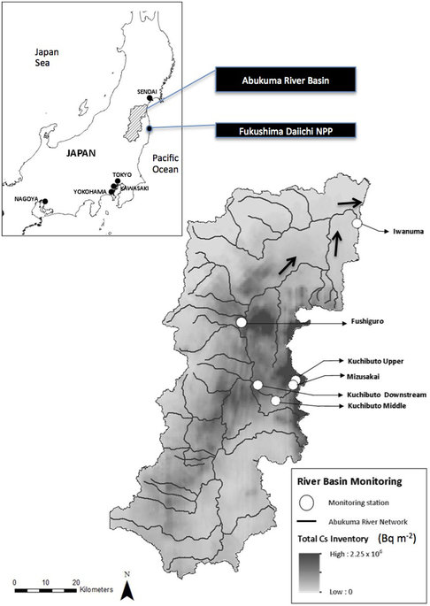
Map of the Abukuma river basin showing monitoring locations and the total radiocesium inventory
1 This Month

of the week – Nuclear Information and Resource Service
July 16 – 19H BST ATOMIC TIES Webinar!!


22,000+ miles voyaging for nuclear disarmament
and a radiation-free environment https://vfpgoldenruleproject.org/
To see nuclear-related stories in greater depth and intensity – go to https://nuclearinformation.wordpress.com
-
Archives
- July 2026 (125)
- June 2026 (287)
- May 2026 (306)
- April 2026 (356)
- March 2026 (251)
- February 2026 (267)
- January 2026 (308)
- December 2025 (358)
- November 2025 (359)
- October 2025 (376)
- September 2025 (257)
- August 2025 (319)
-
Categories
- 1
- 1 NUCLEAR ISSUES
- business and costs
- climate change
- culture and arts
- ENERGY
- environment
- health
- history
- indigenous issues
- Legal
- marketing of nuclear
- media
- opposition to nuclear
- PERSONAL STORIES
- politics
- politics international
- Religion and ethics
- safety
- secrets,lies and civil liberties
- spinbuster
- technology
- Uranium
- wastes
- weapons and war
- Women
- 2 WORLD
- ACTION
- AFRICA
- Atrocities
- AUSTRALIA
- Christina's notes
- Christina's themes
- culture and arts
- Events
- Fuk 2022
- Fuk 2023
- Fukushima 2017
- Fukushima 2018
- fukushima 2019
- Fukushima 2020
- Fukushima 2021
- general
- global warming
- Humour (God we need it)
- Nuclear
- RARE EARTHS
- Reference
- resources – print
- Resources -audiovicual
- Weekly Newsletter
- World
- World Nuclear
- YouTube
-
RSS
Entries RSS
Comments RSS
