EPA’s new leader lobbied for Colorado uranium company on Bears Ears . Scott Pruitt resigned on Thursday https://durangoherald.com/articles/230585 By Mark Harden As Originally Reported by Colorado Politics, July 6, 2018
The man who will replace Scott Pruitt at the helm of the U.S. Environmental Protection Agency – at least temporarily – is a former lobbyist who represented a Colorado uranium company.
Andrew Wheeler was narrowly confirmed by the Senate as EPA’s deputy administrator in April despite opposition from environmentalists and most Senate Democrats. He will step in as acting administrator on Monday following Thursday’s resignation of Pruitt in the face of a storm of controversy over his conduct in office.
Wheeler, 53, could serve as acting administrator for more than a year without further Senate action.
As NPR’s Rebecca Hersher noted in a March report, Wheeler “has spent much of his career working for less oversight from the agency” he will now lead.
Between 2009 and this year, Wheeler was a consultant and lobbyist, often representing large energy companies.
Wheeler has worked as a registered lobbyist for, among others, a major uranium mining company – Energy Fuels Resources Inc. – based in Colorado. Last year, the company lobbied to shrink Bears Ears National Monument.
Colorado Public Radio’s Stephanie Wolf reported last December that the Lakewood-based company – also known as Energy Fuels Inc. – “owns a conventional uranium processing mill and a mine just outside the original boundaries of Bears Ears,” and that the company wrote a letter to the U.S. Department of the Interior, which runs Bears Ears, “expressing concerns that operations might be disrupted or limited by the monument’s original boundaries.”
Fortune magazine says that “while working as a lobbyist, Wheeler worked, along with Interior Secretary Ryan Zinke, to open part of Utah’s Bears Ears National Monument for uranium mining.”
Bears Ears was established in late 2016 by then-President Barack Obama near the end of his term in office. Its original size was 1.35 million acres.
The May 25, 2017, letter to the Interior Department from Mark Chalmers, Energy Fuels’ chief operating officer, says:
“We are concerned that the presence of a new national monument literally adjacent to the privately-owned land acquired specifically for constructing and operating a uranium and vanadium processing facility could affect existing and future mill operations.”
The Washington Post reported last December that:
“Energy Fuels Resources did not just weigh in on national monuments through public-comment letters. It hired a team of lobbyists at (law firm) Faegre Baker Daniels – led by Andrew Wheeler … – to work on the matter and other federal policies affecting the company. It paid the firm $30,000 between Jan. 1 and Sept. 30, according to federal lobbying records, for work on this and other priorities. The company’s vice president of operations, William Paul Goranson, joined Wheeler and two other lobbyists, including former congresswoman Mary Bono (R-Calif.), to discuss Bears Ears in a July 17 (2017) meeting with two top Zinke advisers.
President Donald Trump, whose administration has been promoting expansion of nuclear energy as a means to produce electricity, last December reduced the size of Bears Ears monument by 85 percent. At the time, Chalmers issued a statement saying the company has “no intention of mining or exploring anywhere within the originally designated (Bears Ears monument).”
Wheeler also has represented Xcel Energy, Colorado’s largest power utility, which has invested heavily in renewable energy.
A new warning for dangerous levels of radiation in the Vromos Bay near Chernomorets was issued by the health authorities. In Bulgarian and English, a new plate warns that the sandy strip is dangerous, a BBC report showed.
Radiation contamination is high – in individual areas up to 50 times the norm. However, access to the beach is not prohibited, the risk of using it is the responsibility of the people on holiday.
Ore mined decades ago from the nearby Rosen mine were high in uranium. Part of the waste water is discharged into the bay.
“The difference in the content of radionuclides in the sand and in the soil along the sand strip in relation to this terrain compared to the other terrains we are exploring all along the Black Sea is here between 5 and 50 times.” The life of these radioisotope elements until decay is considerable, it exceeds 90-100 years, “explained Verginia Tsanova – Deputy Director, RZI – Burgas.
The effect of staying for a long time on the sand is not immediate, but it can be seen in years, warn health authorities. Small children also risk swallowing sand.
“It has a carcinogenic effect, and it leads to genetic mutations in the genital cells, from there to the offspring, which is extremely dangerous for young people and for pregnant women,” Tsanova added.
Verginia Tsanova stressed that there is no way to ban the use of the beach. “It’s people’s choice, we just have to warn them,” she said.
The beach is without a concessionaire and is preferred by families with children.
A forgotten community The little town in Niger keeping the lights on in France, Beyond Nuclear By Lucas Destrijcker & Mahadi Diouara, 1 July 18 Reprinted with kind permission from African Arguments
Welcome to Arlit, the impoverished uranium capital of Africa.
From Niamey, the capital of the landlocked West African nation of Niger, we call ahead to a desert town in the remote north of the country.
“Journalists? On their way here? It’s been a while”, we hear down the phone from our contact. “We welcome you with open arms, but only on the pretence that you’re visiting to interview migrants on their way to Algeria. If they find out you’re poking your nose in their business, it’s a lost cause.”
That same evening, the public bus jolts as it sets off. Destination: the gates of the Sahara.
The stuffy subtropical heat gradually fades into scorching drought and plains of seemingly endless ochre sands. About two days later, we pass through a gateway with “Arlit” written on it in rusty letters.
The town of about 120,000 inhabitants is located in one of the Sahel’s most remote regions, not far from the Algerian border. The surrounding area is known to be the operating territory of numerous bandits and armed groups, including Islamist militants. It is like an island in the middle of the desert, an artificial oasis with only one raison d’être: uranium………
approximately 150,000 tonnes of uranium have been extracted by the majority state-owned French company Areva, which is now one of the largest uranium producers in the world. The two mines around Arlit – Somaïr and Cominak – account for around a third of the multi-billion-dollar company’s total global production.
France uses this uranium to generate nuclear power, some of which is sold on to other European countries. According to Oxfam, over one-third of all lamps in France light up thanks to uranium from Niger.
However, in contrast to France, Niger has failed to see similar benefits. The West African country has become the world’s fourth largest producer of uranium, which contributes tens of millions to the nation’s budget each year. Yet it has remained one of the world’s poorest and least developed countries, with almost half its 20 million population living below the poverty line. Its annual budget has typically been a fraction of Areva’s yearly revenue.
The main reason for this is the deal struck between Areva and Niger. The details have not been made public, but some journalists and activists such as Ali Idrissa, who campaigns for more transparency in the industry, have seen the agreement. Amongst other things, the documents suggest that the original deal generously exempted Areva from customs, export, fuel, materials and revenue taxes………
Apart from criticising the Nigerien government for not spending its uranium revenue where it is most needed – such as in health care, education and agriculture – Idrissa ( Ali Idrissa, who campaigns for more transparency in the industry ) emphasises the bigger geopolitical picture: “Don’t forget that Niger isn’t just negotiating with a regular company, but with the French state. Their development aid, military and political support means that we cannot ignore our former coloniser. Our dependency from France goes hand in hand with crooked business deals.”
Forgotten in the desert
Exhausted from the long journey to Arlit, we’re received in the dingy office of Mouvement Unique des Organisations de la Société Civile d’Arlit (MUOSCA), a local umbrella group for environmental and humanitarian NGOs.
“If either Areva or the government were to find out you’re poking your nose in their business, they’ll go to any length to make your work very difficult”, says MUOSCA’s director Dan Ballan Mahaman Sani as he wipes the sweat from his brow. “Besides that, Westerners are attractive targets in this region.”
Indeed, there is a history of Islamist militant attacks and kidnappings in the area, including some directly targeting Areva. In 2010, seven of the company’s employees were abducted, including five French nationals. In 2013, an attack on the Somaïr mine left one dead and 16 injured.
While the world held its breath as armed groups stepped up operations in the region, Areva, managed to extract over 4,000 tons of uranium, up from two years before, without too much trouble.
Dan Ballan says this illustrates how far the Nigerien uranium industry stands apart from the country’s social environment and how isolated Arlit has become especially amidst regional insecurity.
“International NGOs or UN agencies don’t exist here, and Areva has nothing to fear from the Nigerien government,” he says. “We’re literally a forgotten community, completely left to the mercy of the multinational.”
Finding water
According to Dan Ballan and others, the uranium mining industry has taken a huge toll on Arlit and the region. While Areva has a multi-billion-dollar turnover, the majority of people here live in a patchwork of corrugated iron shelters on sandstone foundations. Poverty is rife. Power outages lasting two or more days are regarded as normal.
Moreover, while the uranium mines consume millions of litres each day, only a small proportion of Arlit’s Nigerien population enjoy running water. A 2010 Greenpeace study estimated that 270 billion litres of water had been used by the mines over decades of operations, draining a fossil aquifer more than 150 metres deep. The depletion of these ancient water reserves has contributed to desertification and the drying up of vegetation.
The water in Arlit, however, is not only scarce. Researchers over the years also suggest that, along with the soil and air, it contains alarming levels of radiotoxins.
Bruno Chareyon, director of the French Commission for Independent Research and Information on Radiation (CRIIAD), has been measuring radioactivity in and around Arlit for over a decade. His studies from 2003 and 2004 suggested that the drinking water contains levels of uranium at ten to hundred times the World Health Organisation’s recommended safety standards.
“Despite these findings, Areva has stated continuously that they haven’t measured any excess radioactivity during their biannual examinations,” he says.
In 2009, Greenpeace conducted their own tests and found that five of six examined wells – all used to get drinking water – contained excess radioactivity as well as traces of toxins such as sulphates and nitrates.
……… Toxic waste
At the bustling local market in Arlit, down some meandering alleyways, there are the normal wares, but among them one finds some more peculiar items: large industrial cogs; parts of metal cranes; digging equipment; and even a dump truck.
“All of these are cast-downs from the mines,” says Dan Ballan. “Useless material finds its way to local merchants, who recuperate it and sell it on. Most of them have no idea of the risks.”
CRIIRAD readings of goods at the market from 2003 and 2004 showed radioactivity levels at up to 25 times the maximum standards. “People buy radioactive material to cook with, build their homes with, or raise their children with,” says Dan Ballan…….
Greenpeace and CRIIRAD confirm that radioactive dust spreads far and wide, sometimes to hundreds of kilometres away. But contrary to claims of a “superfast decay”, they say that while some products have half-lives of just days, others have half-lives of tens of years.
Furthermore, researchers say that radioactive waste is not simply dispersed. “The same radioactive rubble was used in Arlit on more than one occasion for landfills or building roads and homes”, alleges Chareyron. In 2007, CRIIRAD found that some road surfaces had radioactive values over a hundred times standard values.
………. Living with uranium
It is not difficult to come across Arlit residents suffering from serious health problems. ………..
The only hospitals in Arlit are run by Areva, with all the medical staff on the company payroll. The government provides no healthcare here. At the Cominak facility, Dr Alassane Seydou claims to have never diagnosed someone with a disease that could be linked to radiation or toxins. He says that in more than 40 years, not a single case of cancer has been discovered. “All employees are systematically examined, but we haven’t encountered any strange diseases,” he claims.
In 2005, the French law association Sherpa launched an investigation into Areva’s activities in Arlit. Speaking to them, one former employee at Somaïr hospital alleged that patients with cancer had been knowingly miscategorised as having HIV or malaria. The surgeon-in-chief at the hospital denied those claims.
There have been no official, large-scale health studies conducted in Arlit, but some smaller-scale studies give an indication of the prevalence of illness among residents and former Areva employees.
In 2013, the Nigerien organisation Réseau Nationale Dette et Développement interviewed 688 former Areva workers. Almost one quarter of them had suffered severe medical issues, ranging from cancer and respiratory problems to pains in their joints and bones. At least 125 had stopped work because of these health issues.
A similar survey was carried out on French former employees around the same time. In 2012, Areva was found culpable in the death of Serge Venel, an engineer in Arlit from 1978-1985. A few months before his passing, doctors had found that his cancer was caused by the “breathing of uranium particles”. The case went to court, with the judge ordering Areva to pay compensation for its “inexcusable fault”. Before the court of appeals, only the Cominak mine was found responsible.
Following the verdict, Venel’s daughter, Peggy Catrin-Venel, founded an organisation to protect the rights of former Areva employees. As part of this project, she managed to trace around 130 of about 350 French workers who had lived in Arlit at the same time as her father. 60% of those she was able to find information on had already died, most of them from the same cancer as her father.
Standing up
Catrin-Venel continues to fight against Areva, but she is not alone. As shown in the documentary Uranium, L’héritage Empoisonné, Jacqueline Gaudet is also standing up to the company.
She founded the organisation Mounana after she lost her father, mother and husband all to cancer in the space of just a few years. Her husband and father had worked at an Areva uranium mine in Gabon, while her mother lived there in a house built from mining rubble. Their cancers were reportedly caused by excessive exposure to radon, which is released during uranium extraction. In collaboration with lawyers from Sherpa and Doctors of the World, Gaudet’s organisation works to collect testimonies from former employees in order to build cases.
For Michel Brugière, former director of Doctors of the World, it’s still unthinkable that so many employees of the French state-owned company could fall ill like this. Speaking in the documentary, he commented: “How can one allow one’s staff to live and work in such a polluted environment? This is unbelievable. It’s reminiscent of long gone abuses.”
In the same vein, Greenpeace describes Arlit as a forgotten battlefield of the nuclear industry. “There are few places where the catastrophic effects of uranium mining on nearby communities and the environment are felt more distinctly than in Niger”, said researcher Andrea Dixon.
Back in Arlit, the stories of French former employees standing up to Areva are well-known. But the struggle for Nigerien workers to get recognised is even steeper than in Europe. “Both the legal system and the financial means to stand up for our rights are lacking”, says Dan Ballan. “In a couple of years, the uranium reserves will be depleted and Areva will leave, however the pollution and underdevelopment will stay behind.”
He may be right, but Areva will not be going far. About 80km away, a third and enormous new Nigerien uranium mine called Imouraren is being developed. “Lacking any perspective of another job, the workers will eventually move
wherever the mine is”, says the local activist……..
Ken 26 June 18 Only is it much much worse and, more insidious. There are multiple deadly cesium 137 like rdionuclides in Northern Japan. There are thousands of times more life extinguishing radionuclides as evil and potent as the 19 gms of cesium137 in brazil, that destroyed a community and several generations of families.
It is in the water, the soil, the food, the air, the people, their houses, the animals, the plants, their cars. It is everywhere.in Japan.
From the Beyond Nuclear story abput the cesium 137 tragedy in Brazil:
On September 13, 1987, Brazilian scrap metal dealer, Devair Ferreira, unwittingly opened Pandora’s box. Out spilled a bright blue crystalline powder that fell glowing to the floor. Fascinated by the magical iridescence, Ferreira invited family members to his home to see the mysterious substance for themselves. They were entranced. They touched it and passed it around to other friends and relatives.
What none of them knew was that they had just set in motion Latin America’s worst nuclear accident. The blue powder was cesium chloride, encased inside a cesium-137 teletherapy unit that had been left behind in an abandoned cancer treatment hospital in the City of Goiânia, the capital of the State of Goiás. Two jobless youngsters had picked it up, pulled out the heavy lead cylinder containing 19 grams of cesium-137, and sold it to Ferreira.
Ferreira, and his friends and family, soon became sick. His brother Ivo took some of the powder to his house where his six-year old daughter Leide played with the glowing radioactive crystals on the floor just before dinner. When she ate boiled eggs with her contaminated fingers, the deadly cesium-137 entered her body. Twenty two Ferreira family members had direct contact with the cesium-137. But they unwittingly went on to contaminate others.
It is amazing how much damage, 19 gr
Of this evil blue shit cesium 137 did in this town in Brazil. The shit, like cobalt 60, strontium 90, iridium is such a strong gamma emitter it has to be tightly contained in a thick lead box. Yet tons of it and other shit was blown all over japan by the reactor explosions.Decontamination of houses and streets in Goiânia
At least 40 people were hospitalized, and by October 28 four had died. They were Ivo’s daughter Leide and Devair Ferreira’s wife Gabriela — who had first sounded the alarm about the sudden mysterious sicknesses in her extended family — along with two of Devair’s employees.
All of those affected were at first treated at the local hospital like regular patients and were allowed to circulate freely through the city, contaminating others they met, as well as the doctors and nurses who cared for them. For 16 days, no one knew that the cause of their sickness was radiation exposure.
When it finally came to light, Brazil’s National Nuclear Energy Commission sent a team to Goiânia, to quarantine and isolate those contaminated and to start the clean-up.
A total of 112,800 people remained isolated in the Olympic Stadium of Goiânia until December 1987, and were examined there for radiation by the CNEN. Radiation technicians ultimately registered a total of 249 contaminated people, 129 of them with cesium-137 in their body, a man-made isotope produced in nuclear reactors that, when ingested, binds with muscle and irradiates people internally.
According to the government of Goiás and the International Atomic Energy Agency (IAEA), Goiânia’s cesium-137 accident claimed only four lives, but the Goiás Public Prosecutor’s Office and the Association of Cesium Victims (AVCesio) say that at least 1,400 people were contaminated and that 66 have died as of 2017.
After the Fukushima nuclear disaster in Japan,Time magazine produced a list of 12 of the Worst Nuclear Disasters. Goiânia was one of them. Yukiya Amano, director general of the IAEA,pointed out in a March 25, 2012 Washington Postcolumn, that the Goiânia incident “involved the unintended release of radioactivity, but it remains the best real-world indicator of what could happen on a larger scale if terrorists were to detonate a dirty bomb in a large city or at a major public event.”
On September 13, 1987, Brazilian scrap metal dealer, Devair Ferreira, unwittingly opened Pandora’s box. Out spilled a bright blue crystalline powder that fell glowing to the floor. Fascinated by the magical iridescence, Ferreira invited family members to his home to see the mysterious substance for themselves. They were entranced. They touched it and passed it around to other friends and relatives.
What none of them knew was that they had just set in motion Latin America’s worst nuclear accident. The blue powder was cesium chloride, encased inside a cesium-137 teletherapy unit that had been left behind in an abandoned cancer treatment hospital in the City of Goiânia, the capital of the State of Goiás. Two jobless youngsters had picked it up, pulled out the heavy lead cylinder containing 19 grams of cesium-137, and sold it to Ferreira.
Ferreira, and his friends and family, soon became sick. His brother Ivo took some of the powder to his house where his six-year old daughter Leide played with the glowing radioactive crystals on the floor just before dinner. When she ate boiled eggs with her contaminated fingers, the deadly cesium-137 entered her body. Twenty two Ferreira family members had direct contact with the cesium-137. But they unwittingly went on to contaminate others.
Decontamination of houses and streets in Goiânia
At least 40 people were hospitalized, and by October 28 four had died. They were Ivo’s daughter Leide and Devair Ferreira’s wife Gabriela — who had first sounded the alarm about the sudden mysterious sicknesses in her extended family — along with two of Devair’s employees.
All of those affected were at first treated at the local hospital like regular patients and were allowed to circulate freely through the city, contaminating others they met, as well as the doctors and nurses who cared for them. For 16 days, no one knew that the cause of their sickness was radiation exposure.
When it finally came to light, Brazil’s National Nuclear Energy Commission sent a team to Goiânia, to quarantine and isolate those contaminated and to start the clean-up.
A total of 112,800 people remained isolated in the Olympic Stadium of Goiânia until December 1987, and were examined there for radiation by the CNEN. Radiation technicians ultimately registered a total of 249 contaminated people, 129 of them with cesium-137 in their body, a man-made isotope produced in nuclear reactors that, when ingested, binds with muscle and irradiates people internally.
According to the government of Goiás and the International Atomic Energy Agency (IAEA), Goiânia’s cesium-137 accident claimed only four lives, but the Goiás Public Prosecutor’s Office and the Association of Cesium Victims (AVCesio) say that at least 1,400 people were contaminated and that 66 have died as of 2017.
After the Fukushima nuclear disaster in Japan,Time magazine produced a list of 12 of the Worst Nuclear Disasters. Goiânia was one of them. Yukiya Amano, director general of the IAEA,pointed out in a March 25, 2012 Washington Postcolumn, that the Goiânia incident “involved the unintended release of radioactivity, but it remains the best real-world indicator of what could happen on a larger scale if terrorists were to detonate a dirty bomb in a large city or at a major public event.”
Main article from beyond nuclearhttp://www.beyondnuclear.org/home/2018/6/20/one-of-the-worlds-worst-nuclear-accidents-was-in-brazil.html
Four nationally known scientists are recommending new testing at a popular Los Angeles-area Jewish camp to determine if contaminants at a nearby former nuclear testing site have posed health risks to past and current campers, NBC Los Angeles reported.
The scientists independently reached that conclusion after reviewing various reports of past testing at Camp Alonim and the land it sits on, the Brandeis-Bardin campus, owned by the American Jewish University. The camp is located just below Santa Susana Field Laboratory, which for decades hosted rocket and experimental nuclear reactor testing. The laboratory has long been closed but is still awaiting a full cleanup, according to NBC. Both AJU and state toxics regulators say the land is safe.
“If you looked at this historically and said, ‘Could being at the camp have led to radiation exposure’ the answer is yes,” said Dr. Jonathan Samet, an internationally known radiation expert and dean of the Colorado School of Public Health, one of the scientists interviewed.
Among the key findings from the two-year investigation are that the test results cited by the camp and state regulators are either too old or too inconclusive to definitely say whether children are safe from contamination from the Field Lab. The article also claimed a 2016 study paid for by the camp’s owner, to investigate concerns about contamination, is flawed. AJU also says the camp has no history of growing food for children to eat in the potentially toxic soil, a claim challenged by past staff.
The article originally was planned to appear in the Los Angeles Jewish Journal, but according to NBC, the Jewish Journal’s new publisher declined to publish the story.
BNA 14th June 2018 Japan’s plan to reuse soil contaminated with radiation from the
Fukushima-Daiichi nuclear power plant accident for agriculture is sparking
something of its own nuclear reaction. Residents and other critics don’t
want any part of it. https://www.bna.com/blowback-japanese-plan-n73014476527/
A monitoring survey was conducted from August 2011 to July 2016 of the spatiotemporal
distribution in the 400 km2 area of the northern part of Tokyo Bay and in rivers flowing into it of radiocesium released from the Fukushima Daiichi Nuclear Power Plant (FDNPP) accident.
The average inventory in the river mouth (10 km2) was 131 kBq⋅m-2 and 0.73 kBq⋅m-2 in the central bay (330 km2) as the decay corrected value on March 16, 2011. Most of the radiocesium that flowed into Tokyo Bay originated in the northeastern section of the Tokyo metropolitan area, where the highest precipitation zone of 137Cs in soil was almost the same level as that in Fukushima City, then flowed into and was deposited in the Old-Edogawa River estuary, deep in Tokyo Bay.
The highest precipitation of radiocesium measured in the high contaminated zone was 460 kBq⋅m-2. The inventory in sediment off the estuary of Old-Edogawa was 20.1 kBq⋅m-2 in August 2011 immediately after the accident, but it increased to 104 kBq⋅m-2 in July 2016. However, the radiocesium diffused minimally in sediments in the central area of Tokyo Bay in the five years following the FDNPP accident.
The flux of radiocesium off the estuary decreased slightly immediately after the accident and conformed almost exactly to the values predicted based on its radioactive decay. Contrarily, the inventory of radiocesium in the sediment has increased.
It was estimated that of the 8.33 TBq precipitated from the atmosphere in the catchment regions of the rivers Edogawa and Old-Edogawa, 1.31 TBq migrated through rivers and was deposited in the sediments of the Old-Edogawa estuary by July 2016. Currently, 0.25 TBq⋅yr-1 of radiocesium continues to flow into the deep parts of Tokyo Bay.
Climate Central By Mikayla Mace, Arizona Daily Star 10 June 18
A group of scientists, including one from the University of Arizona, has new findings suggesting Antarctica’s Southern Ocean — long known to play an integral role in climate change — may not be absorbing as much pollution as previously thought.
To reach their contradictory conclusion, the team used state-of-the-art sensors to collect more data on the Southern Ocean than ever before, including during the perilous winter months that previously made the research difficult if not impossible.The old belief was the ocean pulled about 13 percent of the world’s carbon dioxide — a greenhouse gas that contributes to climate change — out of the atmosphere, helping put the brakes on rising global temperatures.
Some oceanographers suspect that less CO2 is being absorbed because the westerlies — the winds that ring the southernmost continent — are tightening like a noose. As these powerful winds get more concentrated, they dig at the water, pushing it out and away.
Water from below rises to take its place, dragging up decaying muck made of carbon from deep in the ocean that can then either be released into the atmosphere in the form of CO2 or slow the rate that CO2 is absorbed by the water. Either way, it’s not good.
The Southern Ocean is far away, but “for Arizona, this is what matters,” said Joellen Russell, the University of Arizona oceanographer and co-author on the paper revealing these findings. “We don’t see the Southern Ocean, and yet it has reached out the icy hand.”
Oceans, rivers, lakes and vegetation can moderate extreme changes in temperature. Southern Arizona has no such buffers, leaving us vulnerable as average global temperatures march upward.
“Everybody asks, ‘Why are you at the UA?’” Russell said about studying the Southern Ocean from the desert at the University of Arizona. She said the research is important to Arizona and the university supports her work.
…….. scientists know less about the Southern Ocean than the rest of the world’s oceans. What they do know is mostly limited to surface CO2 levels in the summer, when it’s safer to take measurements by ships with researchers aboard. Shipboard sensors that directly measure CO2 are the accepted scientific standard in these types of studies.
Understanding CO2 levels within the air, land and sea and how it is exchanged between the three is necessary for making more accurate future climate predictions.
To fill the gap in knowledge, Russell and her team have deployed an array of cylindrical tanks, called floats, that collect data on carbon and more in the Southern Ocean year-round. Russell leads the modeling component of this project called Southern Ocean Carbon and Climate Observations and Modeling, or SOCCOM.
The floats drift 1,000 meters below the surface. Every 10 days, they plunge a thousand meters deeper, then bob up to the surface before returning to their original depth.
For three years, 35 floats equipped with state-of-the-art sensors the size of a coffee cup have been collecting data along the way and beaming it back to the researchers, like Russell in Tucson. Within hours, the data is freely available online.
They measure ocean acidity, or pH, and other metrics to understand the biogeochemistry of the elusive ocean, but not without controversy.
Making a splash
Alison Gray, an oceanographer at the University of Washington, is the lead author on the study. She said there are two reasons the study may contradict what has previously been thought of about the Southern Ocean: The lack of winter-time observations at the ocean by other researchers and the fact that ocean carbon levels might vary throughout the year.
https://inhabitat.com/26000-tons-of-radioactive-waste-sits-at-the-bottom-of-lake-powell/ Located on the Arizona–Utah border, Lake Powell serves the drinking water needs of 40 million people in the Southwest while welcoming over 3 million recreational visitors every year. However, what lies beneath may give pause to those who depend on the lake. OZY reports that silt on the lake bed covers 26,000 tons of radioactive waste. A remnant from the mid-century uranium boom in the American West, the radioactive stockpile is not thought to be particularly dangerous. Still, even trace amounts can increase the risk of anemia, fractured teeth, cataracts and cancer – dangers which can become more threatening if Lake Powell suffers an extended drought.
At the moment, Lake Powell seems safe. “The uranium mill tailings produce a sandy waste that contains heavy metals and radium, which is radioactive, but these tailings have been down there since around the 1950s, with several feet of sediment placed over top of them and the water used as a moderator, or a shield,” Phil Goble, uranium mill and radioactive materials section manager for the Utah Department of Environmental Quality, told OZY. However, the radioactive waste is not entirely benign, particularly if conditions change. “The tailings could potentially become a problem if Lake Powell gets to a very, very low water level or if the lake is drained, and the tailings are exposed,” Goble said. “In this case, if someone were to dig down and expose those tailings, or the wind blows them, or people use the spot for recreational use of off-road vehicles, then there could be a health hazard.”
Lake Powell is a manmade lake carved from the surrounding red rock canyon and has not been completely full since the late 1990s. In the early years of the 2000s, it suffered a serious drought in which water levels dropped nearly 100 feet, or one-fifth of the lake’s full depth. Given the increased threat of climate change-related drought, it is not so difficult to imagine a situation in which Lake Powell’s water level drops enough to expose the radioactive waste to the surface environment. In the meantime, scientists are monitoring the lake while locals are encouraged to keep drinking from and playing in the beautiful body of water.
Milk in parts of Ukraine has radioactivity levels up to five times over the country’s official safe limit, new research shows.
Scientists from the Greenpeace Research Laboratories at the University of Exeter and the Ukrainian Institute of Agricultural Radiology sampled cow’s milk from private farms and homes in the Rivne region, about 200km from the site of the Chernobyl Nuclear Power Plant explosion in 1986. They found levels of radioactive caesium in milk above Ukraine’s safe limit for adults of 100 Becquerel per litre (Bq/L) at six of 14 settlements studied, and above the children’s limit of 40 Bq/L at eight sites.
The highest levels found were about 500 Bq/L – five times over the limit for adults and more than 12 times that for children.
“More than 30 years after the Chernobyl disaster, people are still routinely exposed to radioactive caesium when consuming locally produced staple foods, including milk, in Chernobyl-affected areas of Ukraine,” said Dr Iryna Labunska, of Greenpeace Research Laboratories at the University of Exeter.
“Many people in the area we studied keep cows for milk, and children are the main consumers of that milk.
“Though the level of soil contamination in the studied areas is not extremely high, radioactive caesium continues to accumulate in milk and other foods, such that the residents of these villages are chronically exposed to radioactivity that presents health risks to almost every system in the body – especially among children.”
The researchers say that some simple protective measures could be taken to bring radiation exposure levels below limits at a cost of less than 10 euros per person per year for the 8,300 people living in the six villages with the highest contamination.
Such measures include applying a caesium binder, called Ferrocyn, to cows, mineral fertilisation of potato fields and feeding pigs with uncontaminated fodder.
The cost of this would decrease each year as radiation levels fall – but if no action is taken, the experts warn that milk contamination will continue to exceed the 100?Bq/L adult limit in parts of Ukraine until at least 2040.
“The Ukrainian government has taken some of these measures in the past, but that stopped in 2009,” Dr Labunska said.
“Government and international monitoring needs to take place, along with help for people affected by this radiation.
“This situation should also act as a warning and a reminder of just how long the legacy of nuclear accidents can be.
“Without adequate countermeasures, what may now seem a purely historical event will remain a daily reality for those communities most impacted.”
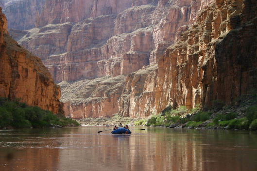
The spectacular and majestic Grand Canyon, eons in the making, needs our help. Some Republican members of Congress want President Donald Trump to overturn a ban on new uranium mining nearby, along with other conservation measures. We need to urge Congress to protect this national jewel.
Some six million people arrive each year to view the vast, multi-hued and intricate canyon, though most don’t venture far from the rim. For them, it’s an inspiring and breath-taking sight. But hardy trekkers who explore remote trails might see something else: signs warning them they are entering an area of the canyon tainted by radioactivity spewed years ago from uranium mines. National Geographic reports uranium leaching from old mines has rendered 15 springs and five wells inside the canyon unsafe to drink. We don’t need more of that.
Uranium pollution is no way to treat an immense and ancient panorama of stunningly varied rock that has been called one of the seven wonders of the natural world. Recently, I had an opportunity to backpack with intrepid family members from the rim to the bottom and camp along Bright Angel Creek, near where it flows into the Colorado River. The ever-changing vista along the rocky trails was magnificent. Unafraid mule deer browsed just a few feet from us. A rare condor flew overhead. Bold rock squirrels waited for a chance to gnaw and rummage through any backpacks absent-mindedly left on the ground.
….. We now have a president who last year ordered federal agencies to review anything that could interfere with domestic energy production. In response, the Forest Service in November recommended reopening land near the Grand Canyon for uranium mining. In March, groups representing the mining industry asked the U.S. Supreme Court to lift the ban on new uranium mining on public land bordering the Grand Canyon National Park.
Uranium mining is extremely risky for the environment. Mining releases radioactive dust into the air and contaminates the land and water with radioactive and toxic substances.
“Uranium mining has left a toxic trail across the West — including at the Grand
Canyon itself,” the environmental group Environment America wrote in its April report update, “Grand Canyon at Risk: Uranium Mining Threatens a National Treasure.”
The waste rock and dirt left behind can remain radioactive for hundreds of thousands of years and also contain toxic chemicals such as arsenic that can contaminate the surrounding environment and make the mines themselves permanently hazardous, the report says.
An analysis of 97 studies by the EU-funded review body EKLIPSE concluded that radiation is a potential risk to insect and bird orientation and plant health.
However the charity Buglife warned that despite good evidence of the harms there was little research ongoing to assess the impact, or apply pollution limits.
the proposed torch route samples had the highest mean radioactivity due to their close proximity to the plant. Based on the measurement, we estimated qualitatively that the radiation exposure of people living near the Azuma Sports Park area was 20.7 times higher than that of people living in Tokyo. The main tourist and proposed torch routes had radiation exposure of 24.6 and 60.6 times higher, respectively, than in Tokyo.
our results showed that the highest radioactivity level was at the proposed torch route, which is located to the northeast of the plant.
Olympic officials should consider using the results of this project to decide whether the radioactivity level at the proposed torch route and the Olympic venues are within acceptable level.
Measuring Radioactivity in Soil and Dust Samples from Japan Fukushima IQP Final Report. An Interactive Qualifying Project Report Submitted to the Faculty of the Worcester Polytechnic Instituteby Thang Pham Steven Franca Son Nguyen
Abstract
A radioactivity map of Cesium-137, a radioactive material emitted from the Fukushima Dai-ichi Nuclear Power Plant, was created by examining 30 soil and dust samples originating from Japan. A Sodium Iodide (NaI) detector measured gamma rays emitted from the samples. Qualitative evaluation of human exposure to radio-cesium in five sets of locations in Japan shows the radioactivity of tested samples. The Fukushima section of one of the Olympic proposed torch route has a 60 times higher activity of Cesium-137 than the activity of the samples from Tokyo.
Acknowledgements…….
Executive Summary
Overview
On March 11th, 2011, a magnitude 9.0 earthquake hit the Fukushima Prefecture of Japan (AESJ, 2015, p.19). This resulted in major structural damage to the surrounding area. Following the earthquake, a 13-meter tsunami hit the Fukushima Dai-ichi Nuclear Power Plant and disabled the backup the diesel backup power generator and the cooling water pumps needed to keep the Power Plant running in the event of a disaster. Since power restoration was unsuccessful and there was major structural damage caused to the Units by the tsunami, there were high concentrations of nuclear particles released into the air.
The amount of radioactive materials emitted from the Power Plant raised health and environmental concerns to the people living in the areas around the Fukushima Dai-ichi Nuclear Power Plant. In fact, several studies conducted after the accident determined the activity of radioactive isotopes in the environments. These studies around Fukushima provided excellent understanding of the activity of radioactive isotopes in the environment and the health effects on humans.
With the upcoming XXXII Olympiad in 2020 hosted by Japan, it is necessary to look into the radioactivity of Olympic venues as well as tourist attractions in the host cities. Previous studies pose a major gap because they focused on regions that are closer to the Fukushima Daiichi Nuclear Power Plant, where the highest concentration of radioactive fallout is located. On the other hand, the radioactivity in other locations in Japan is relatively less studied. Since thousands of athletes and millions of visitors are travelling to Japan for the Olympics, there has been widespread concern from the international community about radiation exposure. Therefore, it is important to investigate the extent of radioactive fallout from the Fukushima Dai-ichi incident.
Project goals and Objectives
The goals of the project were to measure the radioactivity of Cesium-137 in soil and dust samples from Japan and to generate a map that illustrates the activity of Cesium-137 in five locations in Japan.Understanding the radioactivity in Japan soil would help in giving an estimation of human exposure to radioactivity in the studied areas. The primary objectives of this project were to:
Perform soil sample preparation for measurement, including categorizing, drying and sub-sampling
Measure the activity of Cesium-137 in the samples and analyze the radioactivity at different locations in Japan.
Generate a map to illustrate the radioactivity level in Japan soil.
Estimate qualitatively human exposure to radioactivity for people living in the studied areas.
Development of methodology
The employment of various study methods and experiment designs helped complete the objectives. Through literature review and discussion with advisors and lab instructors, we were able to develop main steps and setting for our study.
Primarily, we performed preparation for 87 soil and dust samples collected in Japan and transferred to Worcester Polytechnic Institute (WPI). The samples were classified into five categories based on their original location: Tokyo samples, Azuma Sports Park samples, proposed torch route samples, tourist route samples and non-Olympic samples. All the samples were dried and sub-sampled so that their physical conditions were consistent throughout the testing phase. From the 87 samples that are dried and sub-sampled, we eventually further narrowed to 30 samples for radioactivity measurement.
Previous studies on radioactive nuclides accumulation in soil and dust samples from Japan identified that Cesium-137 had the highest concentration among radionuclides in Japan soil (Saito et al., 2015). Therefore, we set our goal to measure the activity of Cesium-137 in the samples from Japan. A thallium-activated sodium iodine detector, or NaI (TI) detector, measured the concentration of Cesium-137 in the soil samples. The calibrating sources used for Cesium137 measurement were Cesium-137, Sodium-22 and Manganese-54. The experiment reported the radioactivity of the background and the radioactivity of Cesium-137 in the samples above the background. Measurements were made in triplicate to provide counting variability statistics.
At the beginning of the project, samples were selected randomly for measurement. Our focus then shifted, as we looked deeper into the four main areas that will be important to the XXXII Olympiad in 2020. These Olympic areas included Azuma Sports Park, tourist attractions in Tokyo, a proposed torch route, and official designated tourist routes. Time constraint and large amount of samples, limited testing which resulted in results on only a limited part of each sample set.
After finishing measuring, the radioactivity of the soil and dust samples helped generate a map that shows the activity of Cesium-137 in Japan soil. Since there was a large variation in the measured activity between samples at different locations, we decided to analyze the results based on the samples’ original locations.
Our results were cross-referenced with information and results gathered from literature reviews. Understanding the activity of Cesium-137 in Japan soil, we were able to give a qualitative estimation of human exposure.
Results and Analysis
By the end of the project, we were able to measure the activity of Cesium-137 in 30 soil and dust samples. The results showed a great variation in radioactivity between samples from different locations. The activity of Cesium-137 in the 30 samples ranged from 38.6 Bq/kg to 28041.5 Bq/kg with the mean radioactivity of 4903.3 Bq/kg (standard deviation, σ= 6611.0 Bq/kg).
Among the five categories of locations, the Tokyo sample set had the lowest radioactivity mean of 117.6 Bq/kg. The following locations are ordered by increasing mean of radioactivity: Azuma Sports Park samples (2703.9 Bq/kg), main tourist routes samples (3206.0 Bq/kg) and proposed torch route samples (7896.0 Bq/kg). Only one of the non-Olympic samples, which originates from the Entrance to Fukushima Dai-ichi waste mounds, had a radioactivity of 14119.8 Bq/kg. Due to this outlier, this sample set was omitted from the other sets.
The measured results showed that the Tokyo sample set had the lowest radioactivity level, which was understandable based on its significant distance from the Fukushima Nuclear Power Plant. On the contrary, the proposed torch route samples had the highest mean radioactivity due to their close proximity to the plant. Based on the measurement, we estimated qualitatively that the radiation exposure of people living near the Azuma Sports Park area was 20.7 times higher than that of people living in Tokyo. The main tourist and proposed torch routes had radiation exposure of 24.6 and 60.6 times higher, respectively, than in Tokyo.
The results in this study were in agreement with published results qualitatively. Saito et al. reported a much higher deposition of Cesium-137 in the area to the northeast of the Fukushima Nuclear Power Plant and the further away from the plant, the lower the deposition of Cesium-137 (2015). Accordingly, our results showed that the highest radioactivity level was at the proposed torch route, which is located to the northeast of the plant. The further away from the plant for example, in Tokyo and the Azuma Sports Park, the lower the activity of Cesium137. However, because of the differences in sampling techniques and reported unit of radioactivity, there could not be an established direct comparison.
Recommendations
Given the aforementioned results, there is significant evidence through our testing, that there are still high amounts of radiation in areas close to the Fukushima Prefecture. Past and current tests found that high amounts of radiation remain at the origin of the disaster. The results showed a significantly higher amount of radioactive materials in the proposed torch route compared to those in Tokyo.
Given the results from testing, we confidently make the following recommendations:
Further study on the activity of Cesium-137 on the proposed torch route is necessary to understand how much radioactive materials remain.
A more detailed study with more soil and dust samples can give a more accurate map of specific areas of interest.
Olympic officials should consider using the results of this project to decide whether the radioactivity level at the proposed torch route and the Olympic venues are within acceptable level. 4. Qualified health professionals should use this data to make connections about short and long-term effects on health.
Times 11th May 2018 , The environment will have less protection after Brexit because the proposed
new green watchdog will lack the power to hold ministers to account,
conservation groups have said.
Michael Gove, the environment secretary, has
unveiled plans for a new independent statutory body to replace the role of
the European Commission in ensuring compliance with rules on reducing air
and water pollution and protecting wildlife in Britain.
An Environmental Principles and Governance Bill will be published in draft form this autumn
and will establish what the government described as a “world-leading body
to hold government to account for environmental outcomes”. However, unlike
the commission, which can take legal action against the government for
failing to observe environmental laws and impose fines, the new body may
only have the authority to issue advisory notices.
An underground North Korean nuclear test in September last year exploded with 10 times the energy of the atomic bomb that exploded over Nagasaki in 1945.
It also caused the overlying mountain peak to sink by half a metre and shift about 3.5 metres south.
Key points:
North Korea detonated a nuclear bomb under Mt Mantap on September 3, 2017
Using satellite measurements and seismic data, geophysicists calculated the strength of the test and its location — the first time satellite radar has been used this way
The blast was big enough to cause an earthquake and deform the mountain above
These are conclusions drawn by geophysicists, who used satellite radar and instruments that pick up waves travelling through the earth, to calculate the explosion’s depth and strength.
In the journal Science today, they also report signs that a subterranean tunnel system at the test site collapsed 8.5 minutes after the bomb detonated.
In the past, satellite technology — called synthetic radar aperture imagery — has mapped how the ground stretches and warps after earthquakes.
But this is the first time it has been used to examine a nuclear bomb test site, according to Teng Wang, study co-author and a geophysicist at Singapore’s Nanyang Technological University.
Since the United Nations General Assembly adopted the Comprehensive Nuclear-Test-Ban Treaty in 1996, nine nuclear tests have taken place.
Six of these were by North Korea, five of which were at its Mt Mantap facility in the country’s north.
The bombs were detonated in chambers tunnelled into the mountain itself — a granite peak that extends upwards just over 2,200 metres.
But this means the details of the tests, such as the energy produced by the bombs, have been largely unknown outside North Korea — until now.
Eye in the sky, ear to the ground
Dr Wang and his colleagues suspected they could deduce the strength and precise location of the bomb test on September 3 last year, which triggered a magnitude-6.3 earthquake.
Clandestine nuclear activities are tracked by a global monitoring system of sensors that pick up the faint shivers and shudders generated by distant underground blasts and earthquakes.
But while these instruments are capable of picking up the wave signature of a bomb blast thousands of kilometres away, more information is needed to pinpoint exactly where an explosion has taken place.
So in the weeks after the September North Korean bomb test, Dr Wang and his colleagues received images of the Mt Mantap terrain before and after the test, snapped by the German TerraSAR-X satellite.
To map the bumps and dips on the Earth’s entire surface, TerraSAR-X pings radar towards the ground and measures how long it before the signal is bounced back up again.
“As long as the ground is deformed, we can measure it from space using synthetic radar aperture,” Dr Wang said.
Combined with a bit of nifty mathematical modelling — the first time anyone’s modelled an underground nuclear test with radar data — he and his colleagues got a fix on the exact location of the detonation site.
This is a highlight of the work, said Hrvoje Tkalcic, a geophysicist at the Australian National University, who was not involved in the study.
“What’s always difficult is pinpointing an exact location [of a bomb test],” Professor Tkalcic said.
Dr Wang and his team calculated that the top of the mountain subsided about half a metre after the September test, and parts of it shuffled south.
To manage this deformation, the bomb released the energy equivalent to between 109,000 and 276,000 tonnes of TNT in a chamber 450 metres below Mt Mantap’s peak.
The “Fat Man” bomb that exploded over Nagasaki yielded an energy level equivalent to 20,000 tonnes.
Among the data, they found the seismic shivers of a second, smaller event — an aftershock that appeared 700 metres south of, and 8.5 minutes after, the explosion.
The waves produced by the aftershock weren’t consistent with an explosion; rather, it looked like the ground had imploded.
This, the geophysicists suggest, “likely indicates the collapse of the tunnel system of the test site”.
While Dr Wang and his team used data from seismic monitoring systems in China and the surrounding area, Australia has one of the best in the world, Professor Tkalcic said: the Warramunga monitoring station in the Northern Territory, near Tennant Creek.
It’s almost smack bang in the centre of the continent, in an incredibly quiet part of the world, seismically speaking; far from tectonic plate edges, cities and the shoreline, where waves crashing on the coast create seismic noise.
It uses an array of buried instruments to pick up waves that travel through the ground, acting as a giant antenna to amplify weak signals.
“They’re used in the same way as astronomers use arrays of antennas to look at deep space. It’s just that our antennas are pointed to the centre of the earth,” Professor Tkalcic said.
There is also an infrasound detection system at Warramunga station, which detects waves that travel through the atmosphere produced by bomb blasts.
The data is transmitted by satellite to the Comprehensive Nuclear-Test-Ban Treaty Organisation in Vienna, where it is monitored round the clock.
So how do geophysicists know if seismic waves are caused by bomb blasts and not, say, an earthquake or landslide?
In a subterranean explosion, the ground is pushed outwards and compressed, sending a particular type of wave through the ground, Professor Tkalcic said.
An earthquake’s seismic signature is different. If two plates collide, rub against each other or slip, they send out another type of wave.
“We can tell if the first motion was predominantly a compression or if it was a shear type of motion,” Professor Tkalcic said.