Need for Prediction of Marine Heatwaves
|
Need for Prediction of Marine Heatwaves, By Tasmanian Times July 29, 2020 There is need for the development of systems to predict marine heatwaves, say an international research team. The phenomena are a growing threat to marine ecosystems and industries as the climate changes.
Unlike terrestrial heatwaves and other extreme weather events such as cyclones, knowledge of marine heatwaves and their causes is relatively crude, so we don’t yet have tools to predict when they will occur and what their impact will be In a paper published in the journal Nature Reviews Earth and Environment, leading ocean and climate scientists from across Australia and around the world outline the need and potential for marine heatwave prediction. Lead author Institute of Marine and Antarctic Studies (IMAS) Professor Neil Holbrook said dedicated and coordinated research into marine heatwaves only really began following an extreme event off Western Australia in 2011. Subsequent studies have revealed the range of risks they pose. “Over the past century, the global average number of marine heatwave days per year has increased by more than 50 per cent – a trend expected to accelerate under future climate change,” Professor Holbrook said…….. https://tasmaniantimes.com/2020/07/need-predict-marine-heatwaves/ |
|
Lower-latitude oceans drive complex changes in the Arctic Ocean,
The University of Alaska Fairbanks and Finnish Meteorological Institute led the international effort, which included researchers from six countries. The first of several related papers was published this month in Frontiers in Marine Science.
Climate change is most pronounced in the Arctic. The Arctic Ocean, which covers less than 3% of the Earth’s surface, appears to be quite sensitive to abnormal conditions in lower-latitude oceans.
“With this in mind, the goal of our research was to illustrate the part of Arctic climate change driven by anomalous [different from the norm] influxes of oceanic water from the Atlantic Ocean and the Pacific Ocean, a process which we refer to as borealization,” said lead author Igor Polyakov, an oceanographer at UAF’s International Arctic Research Center and FMI.
Although the Arctic is often viewed as a single system that is impacted by climate change uniformly, the research stressed that the Arctic’s Amerasian Basin (influenced by Pacific waters) and its Eurasian Basin (influenced by Atlantic waters) tend to differ in their responses to climate change.
Since the first temperature and salinity measurements taken in the late 1800s, scientists have known that cold and relatively fresh water, which is lighter than salty water, floats at the surface of the Arctic Ocean. This fresh layer blocks the warmth of the deeper water from melting sea ice.
In the Eurasian Basin, that is changing. Abnormal influx of warm, salty Atlantic water destabilizes the water column, making it more susceptible to mixing. The cool, fresh protective upper ocean layer is weakening and the ice is becoming vulnerable to heat from deeper in the ocean. As mixing and sea ice decay continues, the process accelerates. The ocean becomes more biologically productive as deeper, nutrient-rich water reaches the surface.
By contrast, increased influx of warm, relatively fresh Pacific water and local processes like sea ice melt and accumulation of river water make the separation between the surface and deep layers more pronounced on the Amerasian side of the Arctic. As the pool of fresh water grows, it limits mixing and the movement of nutrients to the surface, potentially making the region less biologically productive.
The study also explores how these physical changes impact other components of the Arctic system, including chemical composition and biological communities.
Retreating sea ice allows more light to penetrate into the ocean. Changes in circulation patterns and water column structure control availability of nutrients. In some regions, organisms at the base of the food web are becoming more productive. Many marine organisms from sub-Arctic latitudes are moving north, in some cases replacing the local Arctic species.
“In many respects, the Arctic Ocean now looks like a new ocean,” said Polyakov.
These differences change our ability to predict weather, currents and the behavior of sea ice. There are major implications for Arctic residents, fisheries, tourism and navigation.
This study focused on rather large-scale changes in the Arctic Ocean, and its findings do not necessarily represent conditions in nearshore waters where people live and hunt.
The study stressed the importance of future scientific monitoring to understand how this new realm affects links between the ocean, ice and atmosphere.
###
Co-authors of the paper include Matthew Alkire, Bodil Bluhm, Kristina Brown, Eddy Carmack, Melissa Chierici, Seth Danielson, Ingrid Ellingsen, Elizaveta Ershova, Katarina Gårdfeldt, Randi Ingvaldsen, Andrey V. Pnyushkov, Dag Slagstad and Paul Wassmann.
Antarctic krill threatened by warming waters – climate change’s danger to the marine ecosystem
Climate change threatens Antarctic krill and the sea life that depends on it The Conversation, Devi Veytia, PhD student , University of Tasmania, Stuart Corney, Senior lecturer, University of Tasmania, 19 May 20,
The Southern Ocean circling Antarctica is one of Earth’s richest marine ecosystems. Its food webs support an abundance of life, from tiny micro-organisms to seals, penguins and several species of whales. But climate change is set to disrupt this delicate balance.
What we found
Antarctic krill are one of the most abundant animal species in the world. About 500 million tonnes of Antarctic krill are estimated to exist in the Southern Ocean.
Antarctic krill play a critical role in the ocean’s food webs. But their survival depends on a delicate balance of food and temperature. Scientists are concerned at how climate change may affect their population and the broader marine ecosystem.
Krill growth depends largely on ocean temperature and the abundance of its main food source, phytoplankton (microscopic single-celled plants)………
Krill growth habitat shifted south as suitable ocean temperatures contracted towards the poles. Combined with changes in phytoplankton distribution, growth habitat improved in spring but deteriorated in summer and autumn.
This early end to the growth season could have profound consequences for krill populations. The krill life cycle is synchronised with the Southern Ocean’s dramatic seasonal cycles. Typically this allows krill to both maximise growth and reproduction and store reserves to survive the winter.
A shift in habitat timing could create a mismatch between these two cycles.
For example, female krill need access to plentiful food during the summer in order to spawn. Since larger females produce exponentially more eggs, a decline in summer growth habitat could result in smaller females and far less spawning success.
Why this matters
Krill’s significant role in the food chain means the impacts of these changes may play out through the entire ecosystem.
If krill shift south to follow their retreating habitat, less food would be available for predators on sub-Antarctic islands such as Antarctic fur seals, penguins and albatrosses for whom krill forms a significant portion of the diet.
In the past, years of low krill densities has coincided with declines in reproductive success for these species…….. https://theconversation.com/climate-change-threatens-antarctic-krill-and-the-sea-life-that-depends-on-it-138436
Negative reputation for Fukushima fishing industry – recovery is a long way away
 Fukushima Fishing Industry Still Far from Recovery https://www.nippon.com/en/japan-data/h00664/fukushima-fishing-industry-still-far-from-recovery.html Mar 9, 2020 [excellent graphs] While fishing ports and other infrastructure in Fukushima Prefecture have made progress toward recovery, the area still suffers from a negative reputation.
The coastal area off Ibaraki and Fukushima Prefectures, where the Oyashio and Kuroshio Currents meet in the Pacific Ocean, is an excellent fishing ground. The seafood caught in this area became known as Jōban-mono and was prized by professional chefs and Tsukiji Market connoisseurs. However, the 2011 Great East Japan Earthquake had a profound effect on the local fishing industry, when it caused a tsunami that destroyed all the fishing ports and led to an accident at the Fukushima Daiichi Nuclear Power Plant that damaged the reputation of the waters.
According to Fukushima Prefecture sea-fishing industry statistics, the total catch in 2010 stood at 38,600 tons, before plummeting in 2011. While fishing ports and other infrastructure have steadily recovered since, catches remain low. In 2018, 5,900 tons of fish were caught, equivalent to only 15% of the volume prior to the earthquake. This was worth ¥796 million, or only 7.3% of the ¥11.0 billion generated in 2010. (Aggregated data for 2019 is due to be released later in March 2020.)
After the nuclear accident, the fishing industry in Fukushima came to a standstill for approximately one year. Then, in June 2012, trial fishing operations began. Currently, there are still no catches within a 10-kilometer radius of the Daiichi plant and any made outside that area are subject to prefectural inspections for radioactive materials, alongside inspections by the fishing cooperatives themselves, in order to ensure safety. Although there have been zero cases of results for prefectural inspections outside acceptable levels for more than four years, the area’s negative reputation remains, so full recovery in the fishing industry is yet to be seen .
Huge rise predicted for Britain’s seas and tidal rivers
 Times 23rd Feb 2020, Britain should be preparing for its seas and tidal rivers to rise by up to 6½ ft in the next 80 years, according to the scientist in charge of protecting Holland against flooding and sea level change. Peter Glas, head of Holland’s Delta Programme, which oversees long-term flood risk management, will tell a UK conference that the rise in the level of the Times 23rd Feb 2020, Britain should be preparing for its seas and tidal rivers to rise by up to 6½ ft in the next 80 years, according to the scientist in charge of protecting Holland against flooding and sea level change. Peter Glas, head of Holland’s Delta Programme, which oversees long-term flood risk management, will tell a UK conference that the rise in the level of theNorth Sea may accelerate sharply from 2050, potentially reaching 2 metres (6½ ft) by 2100. That is nearly double the Met Office’s worst-case
predictions. It follows research at Holland’s Deltares centre, commissioned by the Delta Programme, into the impact of rising sea levels on northern Europe. “The rise could potentially accelerate with effect from 2050, entailing far-reaching consequences,” said Glas’s latest report to the Dutch government, which he will cite at this week’s Floodex conference in Peterborough. The Delta report added that effects of “the more rapid melting of Antarctic ice sheets” had not yet been incorporated into the programme’s predictions. |
|
|
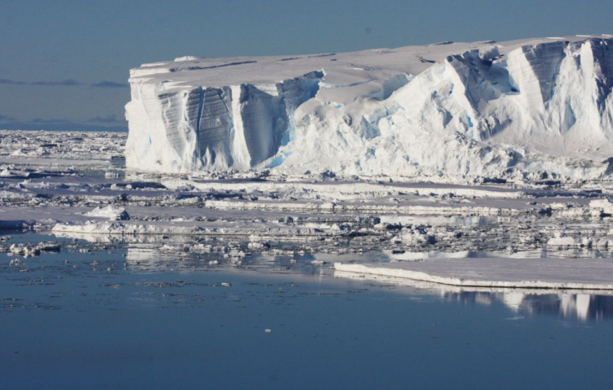
Giant iceberg ‘calves’ from Antarctic ice shelf

Shrinking Antarctic ice shelf Pine Island Glacier sheds giant iceberg, ABC News, Digital Story Innovation Team By Mark Doman 14 Feb 20, In one of the fastest-changing areas of the Antarctic ice sheet, satellites have captured the formation of a giant, 300-square-kilometre iceberg.
Researchers monitoring satellite imagery of the Pine Island Glacier (PIG), in west Antarctica, first noticed two large rifts forming in the shelf in 2019.
Over the next few months, as the glacier moved out towards the Amundsen Sea, the rifts expanded, eventually leading to the splitting of the iceberg from the glacier on February 9.
Within a day, the iceberg had broken up into smaller pieces.
Only one of the pieces was large enough to be named (B-49) and tracked by the United States National Ice Centre.
It comes just days after a station on the Antarctic Peninsula logged its hottest day on record, registering a temperature of 18.3 degrees Celsius.
The peninsula, which juts out to the north-east of the Pine Island Glacier, is among the fastest-warming regions on the planet. Temperatures there have increased almost 3C over the last 50 years, according to the World Meteorological Organisation.
Last month, scientists also recorded unusually warm water beneath the Thwaites Glacier, a neighbour to Pine Island.
While the calving of icebergs from shelves such as the Pine Island Glacier is a natural process in the life of a giant glacier, the rate at which this glacier and others in the region have been disintegrating is a cause of concern for scientists.
Previously the ice shelf calved once a decade. By the early 2000s, it started calving once every five years. But since 2013, the glacier has calved five times, according to Stef Lhermitte, a remote sensing scientist from the Delft University of Technology in the Netherlands……. https://www.abc.net.au/news/2020-02-13/antarctic-ice-shelf-pine-island-glacier-sheds-giant-iceberg/11957770
Polynesian MP calls on France for “vast project” to withdraw radioactive waste in Mururoa

|
Polynesia: MP Moetai Brotherson asks Macron for a “vast project” to withdraw radioactive waste in Mururoa, 8 Feb 2020 https://la1ere.francetvinfo.fr/polynesie-depute-moetai-brotherson-demande-macron-vaste-projet-retrait-dechets-radioactifs-mururoa-798235.html [machine translate] The deputy of Polynesia Moetai Brotherson asked in a letter to Emmanuel Macron, who will be in April in the Polynesian archipelago, that he undertakes on “a vast project of withdrawal and reprocessing of all radioactive waste and residues from the Moruroa nuclear tests “.
From 1966 to 1996, the Mururoa and Fangataufa atolls were the scene of 193 nuclear tests , which had effects on the health and the environment of the populations. The head of state is expected to visit Polynesia in mid-April, when two summits are being held, “France-Oceania” and “One Planet Summit”.
” Mr. President, rather than ostrich, the French Republic would be honored to commit today to an ambitious and vast project to withdraw and reprocess all radioactive waste and residues from the tests Moruroa nuclear “, explains the deputy attached to the communist group in the Assembly and representative of Tavini Huiraatira, Polynesian separatist party, in a letter which AFP had a copy on Friday. Threats of collapse
He recalls that nuclear tests, ” especially in their underground part, generated a quantity of radioactive waste and residues “. ” Today, a significant proportion of this waste is stored in wells several hundreds of meters deep drilled in the coral ring of Moruroa, or worse, at the bottom of its lagoon, in particular at a place called ‘Colette bench ‘ “.
But ” cracks in the base of the atoll “, “induced by underground tests in particular “, threaten ” collapse part of the atoll. It appears that both the containment wells, as the Colette bank are precisely in the endangered area “,
“Dramatic message”For the Polynesian deputy, not to commit to the depollution of the site ” would be to send a dramatic message to the Polynesians, to the Peoples of the Pacific, but also to the People of France, in particular to his youth who wants to see (…) real strong actions in favor of the environment “. Moetai Brotherson underlines that ” the biggest investment made by the State in French Polynesia in recent years is the TELSITE geomechanical surveillance project of Moruroa. The billions invested still come to underline the reality of this collapse, real sword of Damocles, for the Polynesians first, for the Pacific region then, for the reputation of the French Republic finally
|
|
With 170 tons more radioactive water added each day, Japan’s desperate plan for dumping Fukushima water into Pacific Ocean
According to Kyodo News, officials from the Ministry of Economy, Trade, and Industry claimed releasing the water and evaporating it are both “feasible methods” but said the former could be done “with certainty” because radiation levels could be monitored.
There’s more than one million tons of contaminated water already stored at the plant, with 170 tons more added each day. Utility TEPCO says there will be no more capacity for tanks holding contaminated water by 2022.
As Agence France-Presse reported, “The radioactive water comes from several different sources—including water used for cooling at the plant, and groundwater and rain that seeps into the plant daily—and is put through an extensive filtration process.”
That process still leaves tritium in the water and “has been found to leave small amounts of other radioactive materials,” Kyodo added.
The session for embassy officials followed Friday’s recommendation by a Japanese government panel that releasing the water into the ocean was the most feasible plan. As Reuters reported Friday:
The panel under the industry ministry came to the conclusion after narrowing the choice to either releasing the contaminated water into the Pacific Ocean or letting it evaporate—and opted for the former. Based on past practice it is likely the government will accept the recommendation.
Local fishermen oppose the plan and Reuters noted it is “likely to alarm neighboring countries.”
They’re not alone.
Nuclear policy expert Paul Dorfman said Saturday, “Releasing Fukushima radioactive water into ocean is an appalling act of industrial vandalism.”
Greenpeace opposes the plan as well. Shaun Burnie, a senior nuclear specialist the group’s German office, has previously called on Japanese authorities to “commit to the only environmentally acceptable option for managing this water crisis, which is long-term storage and processing to remove radioactivity, including tritium.
Why Arctic glaciers are melting away at an accelerating rate
How the ocean is gnawing away at glaciers, https://www.sciencedaily.com/releases/2020/02/200203114350.htm
- Date:
- February 3, 2020
- Source:
- Alfred Wegener Institute, Helmholtz Centre for Polar and Marine Research
- Summary:
- The Greenland Ice Sheet is melting faster today than it did only a few years ago. The reason: it’s not just melting on the surface — but underwater, too. AWI researchers have now found an explanation for the intensive melting on the ice’s underside, and published their findings in the journal Nature Geoscience.
-
The glaciers are melting rapidly: Greenland’s ice is now melting seven times faster than in the 1990s — an alarming discovery, since climate change will likely intensify this melting in the future, causing the sea level to rise more rapidly.
Accordingly, researchers are now working to better understand the underlying mechanisms of this melting. Ice melts on the surface because it is exposed to the sun and rising temperatures. But it has now also begun melting from below — including in northeast Greenland, which is home to several ‘ice tongues’. Each tongue is a strip of ice that has slid down into the ocean and floats on the water — without breaking off from the land ice. The longest ice tongue, part of the ’79° North Glacier’, is an enormous 80 km long. Over the past 20 years, it has experienced a dramatic loss of mass and thickness, because it’s been melting not just on the surface, but also and especially from below.
-
Too much heat from the ocean
A team led by oceanographer Dr Janin Schaffer from the Alfred Wegener Institute, Helmholtz Centre for Polar and Marine Research (AWI) in Bremerhaven has now identified the source of this intense underwater melting. The conclusions of their study, which the experts have just released in the journal Nature Geoscience, are particularly unsettling because the melting phenomenon they discovered isn’t unique to the 79° North Glacier, which means it could produce similar effects elsewhere. For the purposes of the study, the researchers conducted the first extensive ship-based survey of the ocean floor near the glacier, which revealed the presence of a two-kilometre-wide trough, from the bottom of which comparatively warm water from the Atlantic is channelled directly toward the glacier. But that’s not all: in the course of a detailed analysis of the trough, Janin Schaffer spotted a bathymetric sill, a barrier that the water flowing over the seafloor has to overcome. Once over the hump, the water rushes down the back of the sill — and under the ice tongue. Thanks to this acceleration of the warm water mass, large amounts of heat from the ocean flow past the tongue every second, melting it from beneath. To make matters worse, the layer of warm water that flows toward the glacier has grown larger: measured from the seafloor, it now extends 15 metres higher than it did just a few years ago. “The reason for the intensified melting is now clear,” Schaffer says. “Because the warm water current is larger, substantially more warmth now makes its way under the ice tongue, second for second.”
Other regions are also affected
In order to determine whether the phenomenon only manifests at the 79° North Glacier or also at other sites, the team investigated a neighbouring region on Greenland’s eastern coast, where another glacier, the Zachariæ Isstrøm, juts out into the sea, and where a large ice tongue had recently broken off from the mainland. Working from the surface of an ice floe, the experts measured water temperatures near the ocean floor. According to Schaffer: “The readings indicate that here, too, a bathymetric sill near the seafloor accelerates warm water toward the glacier. Apparently, the intensive melting on the underside of the ice at several sites throughout Greenland is largely produced by the form of the seafloor.” These findings will ultimately help her more accurately gauge the total amount of meltwater that the Greenland Ice Sheet loses every year.
Story Source:
Materials provided by Alfred Wegener Institute, Helmholtz Centre for Polar and Marine Research. Note: Content may be edited for style and length.
New interactive flood-risk map shows that global vulnerability to sea level rise is worse than previously understood.

Eastern Daily Press 23rd Jan 2020, Huge swathes of the Broads, the Fens and even parts of Great Yarmouth and Norwich could be under water in 30 years unless drastic action is taken to halt global warming.
That is the shocking conclusion drawn from a new
interactive flood-risk map built by US-based researchers who claim that
global vulnerability to sea level rise is worse than previously understood.
Australian bushfire smoke across the Pacific shows how French nuclear tests spread radiation
fallout from nuclear tests affected islands such as Tahiti. Smoke from Australia this month drifted over the south of French Polynesia after crossing New Zealand.
Mr Temaru said this was more than proof that fallout from France’s atmospheric nuclear weapons tests at Moruroa spread while France maintained they didn’t affect Tahiti.
He again called on France to tell the full truth about this dark chapter of history.
Until 1974 France detonated 46 atomic bombs over Moruroa and Fangataufa before continuing the tests with underground blasts.
France maintained until a decade ago that its nuclear tests were clean and posed no risk to human health.
A law brought in in 2010 offered compensation but its criteria were widely seen as too narrow because most applications by those suffering poor health were thrown out.
Its revision was changed again, leaving veterans organisations still dismayed. Mr Temaru made the comments as his Tavini Huiraatira party campaigned for the March municipal election.
However, Mr Temaru is yet to say whether he will seek re-election to the mayoralty of Faaa which he has held since 1983.
Among the candidates known so far are two assembly members of the ruling Tapura Huiraatira party.
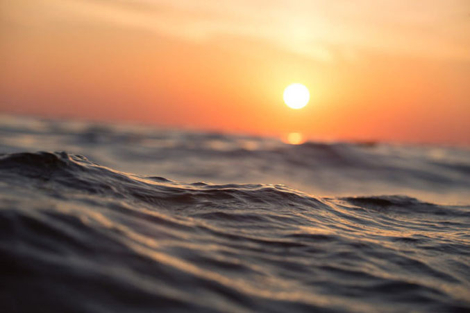
The oceans are getting hot
|
Each year, unfathomable amounts of energy are added to the oceans. Scientists measure heat in joules; the amount of heat in the oceans is so large that we report it in zettajoules. What is a zettajoule? It is 1,000,000,000,000,000,000,000 joules. The amount of heat we are putting into the oceans is equivalent to about five Hiroshima atom bombs of energy every second.
I am part of the team of researchers that published a paper on ocean warming that shows the total heat of Earth is increasing with global heating, as scientists have predicted for decades. Each year, we take Earth’s temperature to try to determine what is happening to our climate. Each year the news is worse than the year before. There is hope, which I will discuss later. But first, let’s talk about the new study. As humans emit heat-trapping gases into the atmosphere, it creates an energy imbalance. There is more heat coming in than going out. That means the Earth is out of balance, and temperatures are rising. The vast majority of the excess energy – more than 90% – ends up in the oceans. Consequently, ocean temperatures are rising, and we can measure it. Global warming is really ocean warming, and it has severe consequences. First, it makes ocean levels rise, because warming water expands. Scientists estimate that by the year 2100, oceans will be about 3ft higher than they were in the year 2000, displacing 150 million people around the world. Warmer oceans also make our weather more extreme. They supercharge typhoons and hurricanes. They make rains more deadly and flooding more severe. The rising temperatures are also threatening sea life. We are experiencing major die-offs of coral reefs, which are incredibly important to ocean biodiversity. Rising ocean water is not just a problem for fish and sea life, it is a problem for everyone. The leader of our team, Dr Lijing Cheng, developed an innovative way to measure ocean temperatures. We only get data where we place temperature sensors, and sophisticated mathematics are used to fill in the gaps and create a continuous picture of what is happening. His method of filling in the data gaps has been shown to be very accurate and scientists around the world have adopted the techniques. Often when scientists report climate data, they try to show trends. It isn’t so important what the ocean temperatures were last year or what they will be this year. What really matters is the trend: are the oceans getting hotter or colder? Using the late 1990s as a reference, we see that years prior are colder and years after are warmer. In fact, we see that the oceans have warmed continuously since about 1990. This long-term trend is what climate breakdown looks like, and it is terrible news for the future of the planet. All reasonable people know that the climate is warming and humans are the cause. Sometimes, I am asked for proof of warming, and there are many things I can point to: ice is melting, air temperatures are increasing, sea levels are rising, etc. But the best proof of warming is in the oceans. No one can dispute the data. The oceans are unequivocally warming. So, what do we do about it? Well, we can begin to use energy more wisely. This will not only help with the climate crisis but save money as well. Secondly, we can maximise our energy from renewable sources such as wind, water, and solar. One of the things that gives me hope is that energy from solar and wind power is now cheaper than dirty coal. The benefits of solar and wind depend, of course, on how sunny or windy the conditions are, but with the drop in green energy prices, it no longer makes economic sense to build coal plants. Another bit of hope is represented by the growing actions of our youth. Make no mistake, the Greta Thunbergs of the world will change things in ways that privileged middle-aged white men like me cannot. Their generation will inherit a dire situation, but they have the passion to act, and decades of unarguable evidence that they must. So yes, 2019 set yet another dire record for Earth’s climate. But the fight continues to make the future more habitable for our children and their children.
|
|
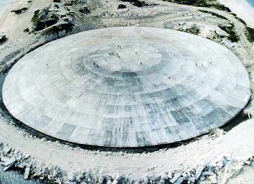
U.S. Congress Demands Investigation Into the U.S.’s Nuclear Coffin, The Runit Dome
|
Congress Demands Investigation Into the U.S.’s Nuclear Coffin, The Runit Dome is leaking radioactive waste into the Pacific Ocean. https://www.popularmechanics.com/military/weapons/a30338371/congress-investigation-runit-dome-nuclear-waste/
Dec 27, 2019
|
|
Seafloor mapping reveals the degradation of ocean floor by Bikini nuclear bomb tests

Bikini Seafloor Hides Evidence of Nuclear Explosions, Seafloor mapping has revealed a crater and several shipwrecks persisting 73 years after the world’s first underwater nuclear test. Eos, Amanda Heidt 28 Dec 19
Seventy-three years after serving as the site of the world’s first underwater nuclear test, the seafloor around the Bikini Atoll remains scarred by finely detailed craters and littered with derelict ships.
Today, an interdisciplinary team of scientists is using sonar to assess the complex submarine environment. The results provide a sobering assessment of humanity’s capacity to alter nature…..
Unleashing the Power of the Atom
In the aftermath of World War II, the U.S. Navy chose the Bikini Atoll for a series of controlled nuclear explosions. Between 1946 and 1958, 23 confirmed tests were conducted throughout the area.
Trembanis and his team studied Able and Baker, a pair of tests conducted in July 1946 as part of Operation Crossroads. Both Able and Baker involved plutonium fission bombs with a yield of between 21 and 23 kilotons, but they were deployed differently……….
Clustering around a laptop, Trembanis and his team witnessed the real-time rendering of an underwater crater more than 800 meters across—big enough to fit three Roman Colosseums. ….
Littered throughout the atoll are the husks of strategically placed ships—decommissioned dreadnaughts, aircraft carriers, and submarines meant to bear the brunt of the Able and Baker explosions. …..
Even independent of their place in nuclear history, the Pilotfish and other Bikini shipwrecks attest to the long-lived effects of human activities on the environment.
As old ships decompose, they become ecological burdens, and researchers found that several wrecks on the Bikini seafloor are leaching plumes of oil. Trembanis and his team looked at sketches from surveys the National Park Service conducted in the late 1980s and saw the degradation of the past 40 years……. https://eos.org/articles/bikini-seafloor-hides-evidence-of-nuclear-explosions
Devastating array of craters on the ocean floor, from nuclear tests
Enormous Craters Blasted in Seafloor by Nuclear Bombs Mapped for the First Time, Live Science, By Mindy Weisberger – Senior Writer 11 Dec FRANCISCO — Today, all seems quiet in the remote Bikini Atoll, a chain of coral reef islands in the central Pacific. But more than 70 years ago, this region’s seafloor was rocked by powerful atomic bombs detonated by the U.S. Army.
For the first time, scientists have released remarkably detailed maps of this pockmarked seabed, revealing two truly massive craters. This new map shows that the seabed is still scarred by the 22 bombs detonated at Bikini Atoll between 1946 and 1958.
The map was presented yesterday (Dec. 9) at the annual meeting of the American Geophysical Union.
During the 1946 nuclear weapons test known as “Operation Crossroads,” the U.S. wanted to test the impact of nuclear bombs on warships. To that end, the Army assembled more than 240 ships — some of which were German and Japanese — that held different amounts of fuel and munitions, then deployed two nuclear weapons to destroy them, researcher Arthur Trembanis, an associate professor with the College of Earth, Ocean, and Environment at the University of Delaware, said in the presentation.
At the time of the tests, Trembanis said, comedian Bob Hope joked grimly:
“As soon as the war ended, we found the one spot on Earth that had been untouched by war and blew it to hell.”……….
But as powerful as the early atomic tests were, they were dwarfed by the later blasts caused by hydrogen and fusion bomb tests in the 1950s. The researchers investigated a crater that was 184 feet (56 m) deep and had an unusual oblong shape; they determined that it was a composite crater from multiple blasts: “Castle Bravo,” a 15-megaton bomb that was the largest ever detonated by the U.S., and “Castle Romeo,” the first deployed thermonuclear bomb.
These tests left behind a uniquely devastating array of shipwrecks and craters, and the first detailed map of their aftermath will help scientists to tell this untold story and connect to “a moment at the dawn of the nuclear age,” Trembanis said. “Our new findings provide insights into previously unknown conditions at Bikini and allow us to reflect on the lasting consequences from these and other tests.” https://www.livescience.com/mapping-reveals-bikini-atoll-nuclear-craters.html
1 This Month


Tell the Ukrainian Government to Drop Prosecution of Peace Activist Yurii Sheliazhenko

Petition to revoke the licensing of the Near Surface Nuclear Disposal Facility (NSDF) at Chalk River. https://www.ourcommons.ca/petitions/en/Petition/Details?Petition=e-7247

of the week – STOP SMALL MODULAR REACTORS IN CANADA
To see nuclear-related stories in greater depth and intensity – go to https://nuclearinformation.wordpress.com
-
Archives
- March 2026 (204)
- February 2026 (268)
- January 2026 (308)
- December 2025 (358)
- November 2025 (359)
- October 2025 (376)
- September 2025 (258)
- August 2025 (319)
- July 2025 (230)
- June 2025 (348)
- May 2025 (261)
- April 2025 (305)
-
Categories
- 1
- 1 NUCLEAR ISSUES
- business and costs
- climate change
- culture and arts
- ENERGY
- environment
- health
- history
- indigenous issues
- Legal
- marketing of nuclear
- media
- opposition to nuclear
- PERSONAL STORIES
- politics
- politics international
- Religion and ethics
- safety
- secrets,lies and civil liberties
- spinbuster
- technology
- Uranium
- wastes
- weapons and war
- Women
- 2 WORLD
- ACTION
- AFRICA
- Atrocities
- AUSTRALIA
- Christina's notes
- Christina's themes
- culture and arts
- Events
- Fuk 2022
- Fuk 2023
- Fukushima 2017
- Fukushima 2018
- fukushima 2019
- Fukushima 2020
- Fukushima 2021
- general
- global warming
- Humour (God we need it)
- Nuclear
- RARE EARTHS
- Reference
- resources – print
- Resources -audiovicual
- Weekly Newsletter
- World
- World Nuclear
- YouTube
-
RSS
Entries RSS
Comments RSS
