California Nuclear Power Stations and the Earthquake Rupture Forecast
“The Great 1857 Fort Tejon Earthquake: The Last “Big One”, Date/Time: January 9, 1857 about 8:20am PST, Magnitude Mw 8.0 approximately Location/Depth: 35.72N 120.32W, Descriptive location: 45 miles NE of San Luis Obispo, Faulting type: right-lateral strike-slip, Faults involved: San Andreas Fault, Length of surface rupture: about 225 miles (360 km), Maximum surface offset about 30 ft (9 meters)”
http://earthquake.usgs.gov/earthquakes/events/1857sca/
USGS Earthquakes over last week (dots), with earthquake hazard UCERF-3/USGS (lines), and Diablo Canyon Nuclear Power Station and San Onofre Nuclear Power Station (More detailed maps below)
“The San Andreas fault, which is more than 700 miles (1100 km) in length, is the boundary between the Pacific and North American tectonic plates…”
San Andreas Fault Photo by Scott Haefner, USGS
“On January 9, 1857, the M 7.9 Fort Tejon earthquake occurred just north of the Carrizo Plain. At Wallace Creek, in the Carrizo Plain…
View original post 1,143 more words
No comments yet.
1 This Month

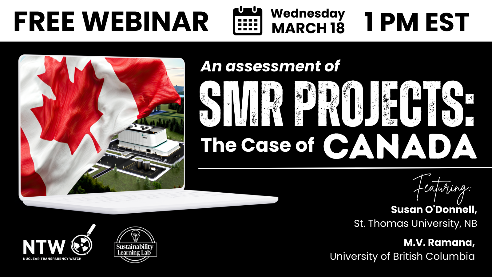
18 March Webinar @ 1 PM EST: An Assessment of SMR Projects: The Case of Canada
register for the zoom:
https://us02web.zoom.us/webinar/register/WN_o8BIIOUvQ2ONJR1nta65DQ#/registration

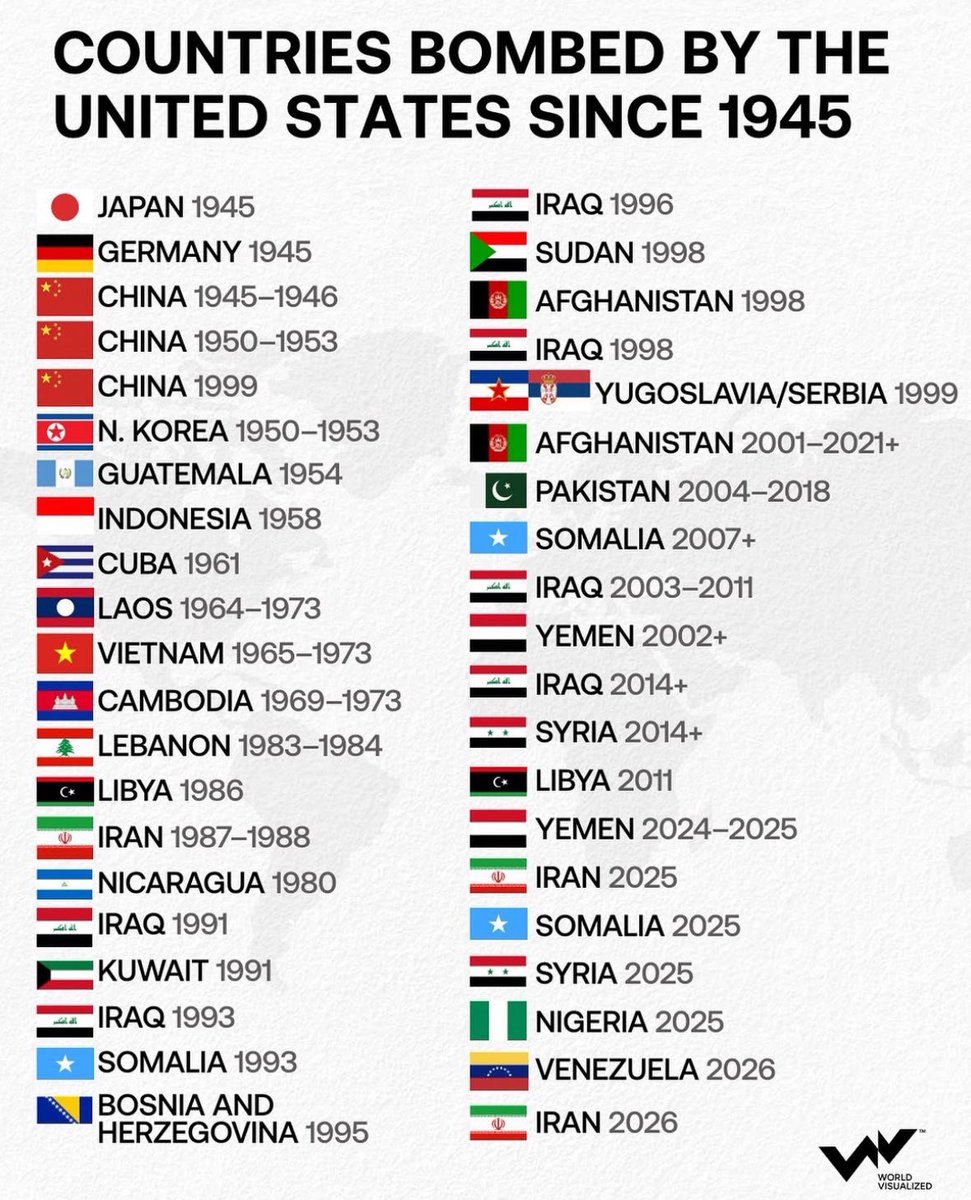
of the week – STOP SMALL MODULAR REACTORS IN CANADA
To see nuclear-related stories in greater depth and intensity – go to https://nuclearinformation.wordpress.com
-
Archives
- March 2026 (140)
- February 2026 (268)
- January 2026 (308)
- December 2025 (358)
- November 2025 (359)
- October 2025 (376)
- September 2025 (258)
- August 2025 (319)
- July 2025 (230)
- June 2025 (348)
- May 2025 (261)
- April 2025 (305)
-
Categories
- 1
- 1 NUCLEAR ISSUES
- business and costs
- climate change
- culture and arts
- ENERGY
- environment
- health
- history
- indigenous issues
- Legal
- marketing of nuclear
- media
- opposition to nuclear
- PERSONAL STORIES
- politics
- politics international
- Religion and ethics
- safety
- secrets,lies and civil liberties
- spinbuster
- technology
- Uranium
- wastes
- weapons and war
- Women
- 2 WORLD
- ACTION
- AFRICA
- Atrocities
- AUSTRALIA
- Christina's notes
- Christina's themes
- culture and arts
- Events
- Fuk 2022
- Fuk 2023
- Fukushima 2017
- Fukushima 2018
- fukushima 2019
- Fukushima 2020
- Fukushima 2021
- general
- global warming
- Humour (God we need it)
- Nuclear
- RARE EARTHS
- Reference
- resources – print
- Resources -audiovicual
- Weekly Newsletter
- World
- World Nuclear
- YouTube
-
RSS
Entries RSS
Comments RSS

Leave a comment