Safecast’s revolution in radiation data collection
Safecast’s software and devices are all open source, and anyone can use the data. Franken says it’s being used by researchers around the world and even by the government in some Japanese cities.
you can tie specific medical symptoms to radiation levels.”
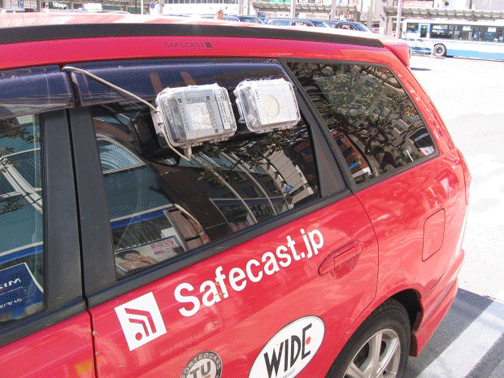
In Japan, Citizen Radiation-Tracking Project Goes Big Time, PRI’s The World, BY CATHERINE WINTER ⋅ MAY 21, 2013 ⋅ON A SUNNY SPRING MORNING JUST OUTSIDE TOKYO, JOE MOROSS HOOKS A RADIATION DETECTOR OUTSIDE THE BACK WINDOW OF A LITTLE RED CAR. HE LOOKS AT A MAP OF THE AREA ON HIS LAPTOP COMPUTER, TRYING TO FIND A ROUTE HE HASN’T DRIVEN BEFORE, SO HE CAN TAKE NEW RADIATION READINGS.
“We want to cover every street so people who look at our maps can drill down and zoom in and find out what the measurement is right in front of their house,” Moross says.
Moross is taking measurements for Safecast. Since the nuclear accident at Fukushima Daichi two years ago, volunteers like him have been driving around Japan, testing radiation and adding their readings to online maps.
When The World last checked in on Safecast, in May of 2011, the group had just formed and had posted a handful of radiation measurements.
Now, Safecast volunteers have taken close to 10 million separate readings…….
Franken demonstrates one of Safecast’s bGeiges. The “b” is for bento box because of the device’s resemblance to a small lunchbox. “So this looks like ordinary kind of thing,” Franken says. “You can clip it on your belt and you can be casual, but inside is a Geiger counter. It has a GPS and a complete computer inside.”
It has a waterproof, shockproof case so it can be attached to a car or bicycle.
Safecast is also working on a drone that can carry a Geiger counter into areas too dangerous for humans.
Safecast has loaned dozens of these devices to volunteers and now offers a kit for people who want to build their own.
All those Geiger counters have gathered a lot of data. Two years ago, Safecast’s map had a lot of blank space. Now, it has more detailed information about radiation in Japan than any other public source. Franken zooms in and out on the online map.
“As you can see, [around] Tokyo, all the roads on the map are basically filled by dots,” he says. The dots are radiation readings. The map is color-coded, so you can see where levels are higher. One thing this data reveals is that being near the nuclear plant doesn’t necessarily put you in danger – and being far away doesn’t necessarily mean you’re safe. Radiation didn’t spread in a tidy circle. There are hot spots here and there, depending on things like how the wind blew and whether there were hills.
“In cities [like] Fukushima City or Koriyama City there are really big differences street by street,” Franken says. “That’s why measurement street by street became more relevant: because my street is not your street and I’m not safe until I know my street is safe.”
The Japanese government also measures radiation, but it doesn’t provide this much detail and doesn’t make it easy to read like this. And not everybody trusts the government data. Safecast’s software and devices are all open source, and anyone can use the data. Franken says it’s being used by researchers around the world and even by the government in some Japanese cities.
“And you can come up with lots of things that can come from it which we can’t imagine today,” he says. “But as it is available suddenly people say, ‘I want to tie this data with this data.’ For example, you can tie specific medical symptoms to radiation levels.”
That kind of research hasn’t been possible in the past……. http://www.theworld.org/2013/05/in-japan-citizen-radiation-tracking-project-goes-big-time/
No comments yet.
1 This Month
Chernobyl: The Lost Tapes – A good documentary on Chernobyl on SBS available On Demand for the next 3 weeks– https://www.sbs.com.au/ondemand/tv-program/chernobyl-the-lost-tapes/2352741955560

of the week–London Campaign for Nuclear Disarmament
Tell the Ukrainian Government to Drop Prosecution of Peace Activist Yurii Sheliazhenko
To see nuclear-related stories in greater depth and intensity – go to https://nuclearinformation.wordpress.com
-
Archives
- April 2026 (139)
- March 2026 (251)
- February 2026 (268)
- January 2026 (308)
- December 2025 (358)
- November 2025 (359)
- October 2025 (376)
- September 2025 (257)
- August 2025 (319)
- July 2025 (230)
- June 2025 (348)
- May 2025 (261)
-
Categories
- 1
- 1 NUCLEAR ISSUES
- business and costs
- climate change
- culture and arts
- ENERGY
- environment
- health
- history
- indigenous issues
- Legal
- marketing of nuclear
- media
- opposition to nuclear
- PERSONAL STORIES
- politics
- politics international
- Religion and ethics
- safety
- secrets,lies and civil liberties
- spinbuster
- technology
- Uranium
- wastes
- weapons and war
- Women
- 2 WORLD
- ACTION
- AFRICA
- Atrocities
- AUSTRALIA
- Christina's notes
- Christina's themes
- culture and arts
- Events
- Fuk 2022
- Fuk 2023
- Fukushima 2017
- Fukushima 2018
- fukushima 2019
- Fukushima 2020
- Fukushima 2021
- general
- global warming
- Humour (God we need it)
- Nuclear
- RARE EARTHS
- Reference
- resources – print
- Resources -audiovicual
- Weekly Newsletter
- World
- World Nuclear
- YouTube
-
RSS
Entries RSS
Comments RSS

Leave a comment